


Weather overview and short term outlook to Friday 21 February 2020
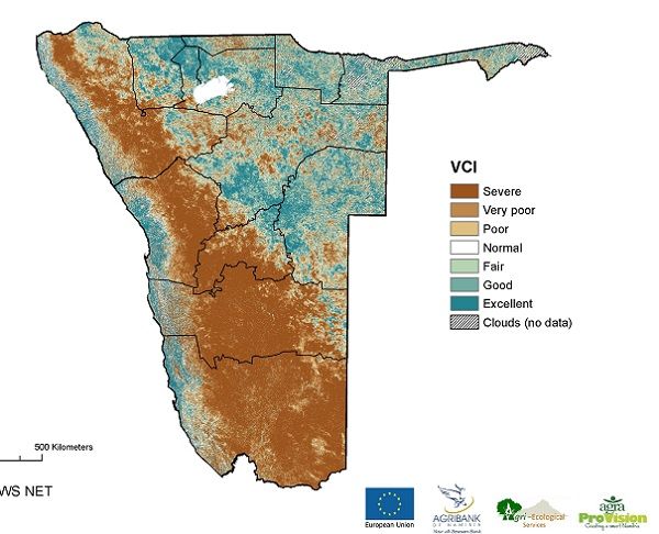
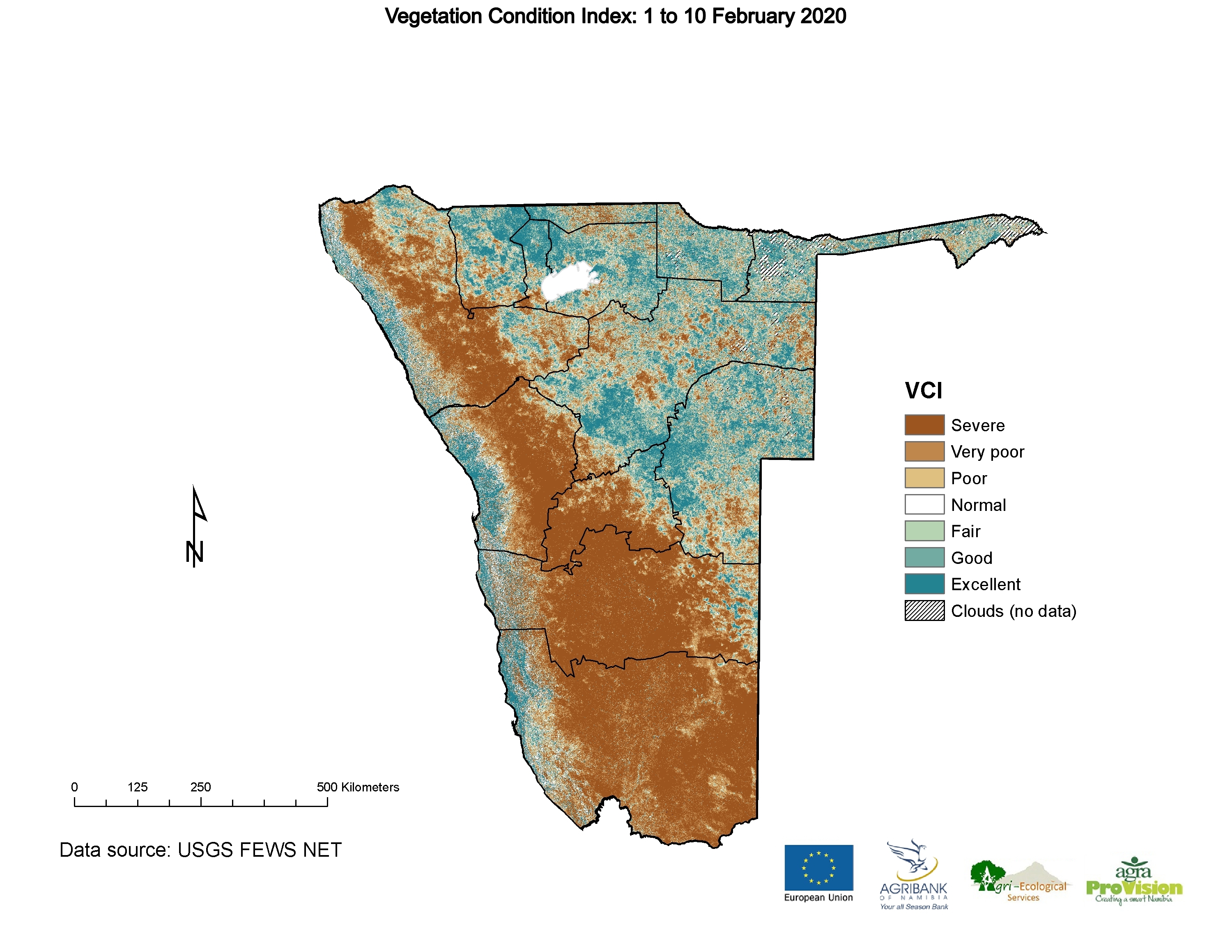
Visual: Condition of vegetation as assessed from 01 to 10 February.
Source: Namibia Rangelands dot Com based on data from the US Geological Survey’s Famine Early Warning System (FEWS).
www.namibiarangelands.com/wp-content/uploads/forage-maps/2020-02-10/2020-02-10-en-na-bg-vc-vci.jpg
Recent Developments
Productive rains over large areas of the interior above (east of) the escarpment brought some relief to many districts over the past four days. Most recorded falls registered between 12 and 20 mm but there must have been very heavy but isolated showers in areas where the rainfall was not recorded as witnessed by the many rivers in flood from Otjozondjupa in the north to the Karasburg district in the south.
This week’s visual is a so-called Vegetation Condition Index based on an assessment of satellite imagery taken over the first decad (ten days) of this month. As such, in our climate, it is representative of precipitation that occurred in the preceding month, i.e. January. As an index, it implies that it is compared to another value that was established earlier. In the case of this visual, the index values are based on the average values from 2000 to 2016.
What the visual shows is that the impact of the drought is still severe. While the last few days have brought a welcome respite, there are still many areas, especially in the west and the south, where the drought continues. One can only hope that the rest of the season improves.
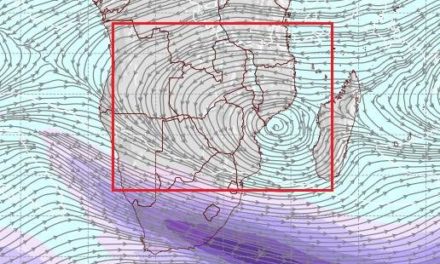
The presence over the weekend of so much moisture and such a low cloud base surprised many. A clue of the moisture’s origin and why it has penetrated so deep into Namibia is provided by the daily synoptic chart of the South African Weather Service.

In the north-west is a low pressure system straddling the Namibia Angola border. Its direction of rotation is clockwise. In the south-west (over South Africa) is a high pressure cell which is the remnant of high pressure ridging earlier last week. This cell’s direction is counter clockwise.
Between the two, indicated by the blue and the red arrows, a constriction zone forms, almost like a funnel, enhancing the flow of air from Angola and Zambia. That it was tropical air that penetrated the Namibian interior could be discerned from the cloud texture, light and fluffy, and the cloud base which came as low as 9000 feet over Windhoek.
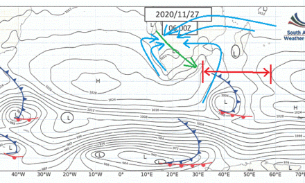
Synoptic maps typically capture surface conditions so one also has to consider what happened higher up in the atmosphere. At the 500 mB surface, the signature mid-level trough developed, advecting moisture from the Angolan interior more or less at 18,000 feet elevation. Furthermore, this trough extended into the stratosphere, meaning that there was a strong airflow from Angola into Namibia and that it reached very high up to about 36,000 feet at the 200 mB surface. It is not often that airflow patterns in the mid-level atmosphere and the troposphere align but when they do, and when they are driven on the surface by a low and a high pressure cell in juxtaposition, then the Namibian interior gets good rain.
On the Radar
The trough stays in situ for the week indicating positive rainfall prospects for the interior above the escarpment. This trough is not expected to grow stronger to the west, as so often happens when the South Atlantic high pressure cell slips around Cape Agulhas, but it is at least expected to remain more or less across the Namibian interior from the Angolan border to the Orange River. This will last until Friday.
The highest and the most widespread rainfall probability is indicated for Wednesday and Thursday.
By the coming weekend, there will be a two-day lull in actual rainfall but by then the South Atlantic high has migrated past the Cape and another bout of positive rainfall conditions will be driven by the anti-cyclonic circulation over the sub-continent.


