Weather overview and short-term outlook to Wednesday 02 December 2020

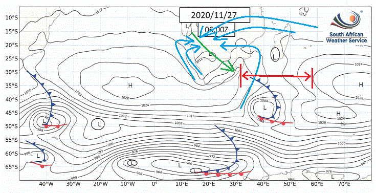
Visual: Synoptic map of the southern African subcontinent on Friday 27 November at 08:00 local time.
Source: South African Weather Service, https://www.weathersa.co.za/home/synopticcharts
Recent Developments
Weatherwise, the past three weeks saw the repetition of the same regular 4 to 5 day pattern, controlled by the South Atlantic high pressure cell, followed by 2 to 3 days with limited incursion from the tropics.
High pressure control on the surface enters the Namibian interior from the south-west. This is marked by somewhat cooler nights and clear, blue skies. In Namibia’s south, the airflow is south-westerly, in the central Namib it is westerly and in the northern Namib and adjacent interior, it is north-westerly. It indicates an absence of moisture over the southern and western two thirds of the country.
As the South Atlantic high migrates to the east, it wraps around the continent, its core passing about 200 km south of Cape Agulhas. Once it has passed this point, it pushes northwards up the Mozambican Channel from where it recurves over the continent leading to brief high pressure control over the eastern half of the subcontinent. The northern perimeter drives the anti-cyclonic circulation over land which is a standard summer feature.
The visual shows conditions early Friday morning. This is at the transition phase where the leading edge of the South Atlantic high has just started dominating conditions in the Mozambican Channel while its trailing edge still controls surface conditions in Namibia.
In Namibia, this regular movement of the high creates two opposing weather fronts as indicated by the blue arrows in the visual. From the south-west comes the direct impact of the South Atlantic high and from the north-east comes the anti-cyclonic circulation. Typically, between the two a trough develops in the mid-level atmosphere marked by a pronounced airflow from the north-west to the south-east and into Botswana and South Africa. This is another common summer feature. In the visual it is indicated by a green arrow.
Rainfall prospects are not positive for Namibia as long as the South Atlantic high maintains its regular pattern. What is required before the rain season can start in earnest is that the distance between the 1024 mB isobars of the Southern Indian high and the South Atlantic high increases. This is indicated by the red line. As can be seen in the visual, currently the distance is around 2500 km. What needs to happen is for this distance to double to around 5000 km. When that shows up on the synoptic maps, then the rain will start.
This week was marked by much activity and instability over the Kavangos and the Zambezi with very little happening further south and west except for the odd light shower in the eastern sections of Otjozondjupa and Omaheke but nowhere did we receive persistent widespread rain.
This is still only the build-up to the main season but there are some promising signs coming from the southward migration of the Inter-Tropical Convergence Zone. If it carries on as over the past month, it should be on the Namibian Angolan border by Christmas which is exactly where we want it at just the right time.
On the Radar
There is some relief during the weekend from the heatwave conditions we had on Thursday and Friday. The mid-level trough is active but displaced to the east. Its current position is more or less from Oshikango to Gam showing that only the north-eastern quadrant has positive conditions.
As the high moves further east, a convergence zone of instability develops over central Angola along a north south line. This should lead to much more widespread cloud formation over the interior but restricted to the northern and eastern halves.
In general, the western and southern two thirds of Namibia will continue with much the same conditions as during this week with the only exception some cloudiness that may appear over the interior above the escarpment.
By next week, the mid-level trough has shifted to the east leaving only limited prospects for rainfall over Kavango East, Zambezi and central Botswana.


