


Fortnightly weather overview and short-term outlook to Wednesday 06 November 2019
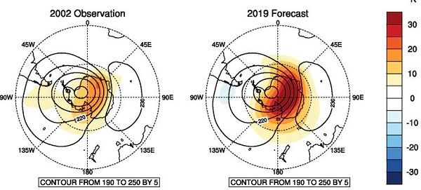
Visual: Comparison of 2002 and 2019 of Antarctic alto level high pressure control.
Source: The Conversation website.
Recent Developments
There is much local expectation regarding the observed warming of air in the upper atmosphere above Antarctica. Like all things weatherwise, this needs to be put in proper perspective.
It is strongly advised that all Namibians interested in this phenomenon, read the article, linked above, by four weather scientists working for the Australian Bureau of Meteorology. Interesting to note is the fact that the article was written for a South African inter-university academic publication but that the focus still remains Australian.
The warming of the Antarctic upper atmosphere in 2002 was not expected. The event was only interpreted after it occurred but with such scientific rigour that the scientists were able to predict this year’s event.
Note also that 2002/03 were not particularly wet years in Namibia but there are some spots in the central interior north of Windhoek that had a spectacular season and there are many readings of around 600mm.
Furthermore, during the 2010/11 season, Namibia’s wettest year on record, there was no observed warming of the atmosphere in Antarctica.
The conclusion is that it is premature to whip up emotions for this coming season by making a comparison to the previous event, and by suggesting (falsely) that there was a similar occurrence in 2011.
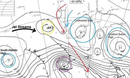
The past two weeks saw a continuation of the rather uneventful late winter / early summer transition with little change in the larger, regional elements. Early in the week, the South Atlantic high pressure cell made a surprise appearance in Namibia, dropping temperatures in the South to well below 15°C with a spillover on Tuesday and Wednesday morning that could be felt as far north as Windhoek.
As the week progressed, the South Atlantic high migrated around the southern Cape, measuring a relatively strong 1024 mB in that part that made landfall hugging the southern Cape littoral. But the real action was behind the high in the form of a strong frontal system anchored by an impressive vortex at its southern tip at about 40°S. This happened about 1500 km south-west of Cape Town but the system had such an impact further north that it brought a thin layer of cloud to the Namibian interior, followed by some cloud built-up on Thursday. By Friday the system had gathered enough strength to produce very promising local conditions in the Bethanie district, the Fish River valley, and further east in the Karasburg district.
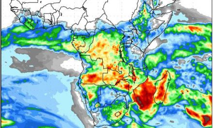
On Friday (01 Nov) a well-developed convergence zone in the Kalahari showed up on satellite imagery with scattered thunder storms near the Botswana border.
This local development was countered by the sub-continental circulation with its pivot more or less over central Zimbabwe. This was also the reason for the excessive temperatures in the Caprivi, Bwabwata, and as far east as Divundu.
It must be noted that the high’s trajectory and strength around the southern Cape displayed a distinct winter stance, very much like last year.
On the Radar
The frontal system passes far south of Cape Town from west to east and loses much of its steam as the South Atlantic high morphs into the southern Indian high.
In Namibia, cloud penetration will be much reduced over the weekend with very little chance of rainfall south of Etosha. Rainfall prospects remain favourable for Kunene, Owamboland and the Kavango with good potential for thunder storms but the high cloud base will prevent good rains.
By next week Monday, another frontal system is approaching the Cape and it can repeat similar conditions in the South as this week. It will lead to excessive windiness over the southern and central Namib and sand storms can be expected.
This system passes the Cape by Monday evening followed closely by the next approaching South Atlantic high but displaced somewhat to the south. This development should improve the chances for the signature mid-level trough to develop from southern Angola, through central Namibia and into South Africa adjacent to the Karasburg district.
Although scattered thunder showers are forecast for the interior, the trough will only develop its full strength by Wednesday next week.
Consequently, scattered thunder showers are expected for the northern half but not in the Kavango , Bwabwata or Caprivi. The bias will be north of Etosha, west of Ekongo and east of Ruacana. Further south, there is a reasonable chance of rain in the north-central, central and south-eastern areas. This all depends on how long the trough stays active and how far it develops to the west.


