


Weather overview and short-term outlook to Wednesday 21 April 21
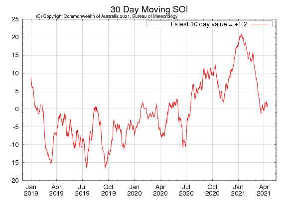
Visual: 30-day moving southern oscillation index.
Source: Australian Bureau of Meteorology, www.bom.gov.au/climate/enso/monitoring/soi30.png
Recent Developments
With a high pressure cell over central Botswana and a surface trough along the Namibian coastal plain, the excruciating Oosweer in Walvis Bay and Swakopmund on Monday and Tuesday was no surprise.
The first portents of this event were noticed during Sunday night in the interior when a fresh easterly wind started blowing. This was repeated during Monday night.
The atmosphere acts like a noble gas so this bit of chemistry is always handy when trying to explain local phenomena. Oosweer as such has been discussed often in this column so there is no need to revisit the technicalities. How it occurs locally is well-understood and can even be predicted as much as two days in advance.
That it will turn into such a major event, was the surprise but again, looking at the synoptics, in hindsight it is clear why temperatures reached 43° C in some places close inshore.
The high in Botswana was not particularly strong, around 1018 mB and the coastal trough was not particularly low, around 1010 mB, but the surface area that the system covered was enormous. The high reached from the Zambezi River all the way across Botswana into South Africa’s Northern Cape Province, And the coastal low stretched from the Kunene to the Orange.
So we are looking at a combined system, spread over more than 1000 kilometres from north to south and another 1000 kilometres from west to east. Given the persistent anti-cyclonic circulation on the high’s rim, it means that this entire airmass, some 15 kilometres deep, was propelled relentlessly to the Namibian interior and from there across the escarpment into the coastal plain.
We are talking about billions of billions of cubic metres of air that is being moved at a fresh pace of about 15 to 20 knots in a westerly direction. The volumes are so huge that it would be better to express total volumes in logarithmic style, but that will be too technical.
Were this airmass allowed to cross deep into the ocean, it would have dissipated naturally over the cooler waters but then it encountered the outer rim of the South Atlantic high pressure cell and it is like hitting a wall. Its movement is stopped right there, perhaps 50 or 60 kilometres offshore.
Meanwhile, in the stratosphere where the so-called jet streams are active, there is a very strong west to east airflow. This acts almost like a lid at the top, containing and preventing the surface system to rise higher than about 40,000 feet.
Since this air cannot escape to the ocean or into the stratosphere, and since it descends from around 1600 metres inland to zero at the coast, it is compressed on a stellar scale. This so-called adiabatic compression releases energy, quickly rising the surface temperate as much as 20°C above normal. This is what happened at the coast
This week’s visual is the latest update of the southern oscillation index, a very reliable indicator of changes in conditions over the Pacific Ocean east of Australia. When this index crosses the +7 point mark, it is usually a good (but inferred) indication of positive rainfall prospects over Namibia.
As can be seen, the index crossed the +20 value in January and we experienced the results. Currently, the index value has retracted to marginally positive but it must be kept in mind that it is a 30-day comparative index, in other words it compares current oceanic and atmospheric conditions to the same conditions one month ago.
The fact that the index went so high in January (the x-axis calibration had to be adjusted twice), means that current measurements come off a very high base so any normalisation tends to produce higher negative values on the downside of the curve. Nevertheless, it shows that the strength of this season’s rain conditions is gone, and that any late rains will only happen sporadically and very isolated.
On the Radar
A relatively strong cut-off low has been forming offshore Oranjemund during the second half of this week. By Friday it was strong enough to show up on satellite imagery.
This cut-off low has a cyclonic circulation acting as a huge suction pump drawing tropical air from Zambia across Botswana into Namibian airspace. Since it is not associated with the customary mid-level trough from Angola into Namibia, it means the southward airflow follows a route through Botswana and only enters Namibia south of Buitepos.
With this in mind, the outlook for the weekend is for lots of clouds east of the escarpment over the central and eastern areas with some cloudiness even reaching the southern Namib.
This lasts only two days and during Monday it will start clearing, taking us back to a late summer, early winter transition.

The cut-off low’s actual development can be seen at the bottom of the sidebar on this page in the green live rain animation.


