


Weather overview and short-term outlook to Wednesday 07 October 2020
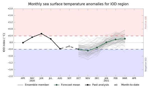
Visual. Ensemble of model predictions for a shift in the Indian Ocean Dipole.
Source: Australian Bureau of Meteorology. http://www.bom.gov.au/climate/enso/#tabs=Indian-Ocean&indian=Outlook
Recent Developments.
A popular misconception has been doing the rounds this week. The spate of cooler weather over the southern half of Namibia was ascribed to the cold front passing the Cape, but it is not true.
As could be seen on the twice-daily synoptic charts of the South African Weather Service, the cold front passed the Cape already the previous weekend, followed by the bulk of the migrating South Atlantic high pressure cell. Then around Tuesday this week, a so-called cut-off low started developing over the sea and land area some 300 km north of Cape Town. This cyclonic circulation was far more pronounced at the 500 mB level (18,000 feet) than on the surface but it did have some effect in the lower strata.
The most important for us was that the northern rim of the cut-off low advected cold, moist air from the Atlantic into the Northern Cape and southern Namibia bringing precipitation to large areas at or near the Orange River Valley. This could be observed by the fact that it rained about 10 mm in Oranjemund and Rosh Pinah but not a drop in Lüderitz and Aus, only some 160 km further north.
This late rain in the south resulted in a phenomenon that happens only very, very rarely, perhaps once in 20 years. While the far south enjoyed some late winter rain on Wednesday and Thursday, it also rained in Kavango East albeit of lesser intensity. Areas east of Rundu up to about 50km into Bwabwata recorded intermittent light showers of anything between 1mm and 5mm. It is really a mix-up of the seasons when it rains on the same day in the north and in the south.
This week’s visual shows the outlook for the so-called Indian Ocean Dipole, an oceanographic event that affects the weather in Malaysia, Australia and Indonesia, as well as the east coast of Africa. The visual shows that the Ozzie met expects the dipole to become briefly negative during November before reverting to neutral and then possibly to positive.
The Indian Ocean Dipole describes the relationship between the sea surface temperatures in the western and eastern Indian Ocean respectively. When the western part (off the African coast) is warmer, the dipole is positive. This implies colder water closer to Australia. When the opposite happens (colder near Africa, warmer near Australia), it is negative.
This is just an academic convention and has nothing to do with either positive or negative expectations for Africa or Australia.
Sadly for us, the Indian Ocean Dipole is not investigated much by local scientists, other than some cursory work in South Africa and some good work in Mauritius.
What it means for Namibia in practise is that a negative dipole (cooler near Africa) retards the onset of the rainy season in eastern and central Africa and since our summer moisture comes from the DRC, Angola and Zambia, rainfall prospects are not that good when the dipole is negative. How it actually develops over the next three months, we will have to wait and see.
On the Radar
Overall conditions for the entire country revert to a normal early summer pattern with cooler temperatures in Hardap and Karas while the northern regions will continue to be very hot.
A significant disturbance in the mid-level atmosphere moves in from the Atlantic during the weekend where it should encounter the anti-cyclonic circulation over the interior. Consequently, a convergence zone forms during Sunday night and there is a slight chance for some light rain in the south but this time in the eastern section of the Karas region.
As the mid-level trough develops in strength and extent, the convergence zone extends from the Angolan border to around the Kgalagadi Transfrontier Park. On Tuesday there is a somewhat improved rain probability along the Botswana border and into Kavango East.
By Wednesday, the mid-level trough has shifted to the east with Bwabwata and the Caprivi directly in its path. There is a reasonable chance for light precipitation in these two areas.


