


Overview for the week and 5-day outlook to Wednesday 11 July 2018

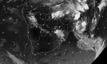
Visual: Southern Africa surface precipitation outlook for Saturday 07 July
Source: http://www.1stweather.com/maps_fx.php
The visual, published both by the Kobus Botha and Namibia Weather websites every day, actually comes from a commercial weather company, Customweather Inc., based in California. Although the latter claims a high level of predictive accuracy, experience has taught us to take their rainfall forecasts for our region with a heavy pinch of salt.
Windhoek woke up on Friday morning with the first fingers of an approaching system already visible in the sky as a thin layer of cloud, seemingly out of the blue, so to speak. But this system did not materialise from thin air, it had a discernible preceding history which developed during the course of the week.
Interestingly, George Mason University’s outlook of a week ago, accurately predicted cloud formation over Namibia on Thursday and Friday but at that point the spread was limited to the north-eastern and eastern section of the country. That it developed so far west and south was a surprise.
At the beginning of the week, the very strong South Atlantic high pressure cell with a core reading of 1032 mB had progressed about halfway across the sub-continent from west to east. Its immediate impact was felt on Monday and Tuesday continuing into Wednesday but then no longer from the primary source. At that point, the continental high started ridging backwards over Botswana crossing into Namibia, bringing the cold in from the east as is very typical for Namibia in the second half of the winter.
This rather complex weather development brought to Namibia the type of weather that one would only expect late in August or early September. The visible result in the interior was an inversion layer that grew bolder during Thursday and blossomed into a full cloud formation that covered about two thirds of the country from Kavango West down to the Karas region on Friday. The only areas with zero cloud formation was the Kunene region and the southern Namib below the escarpment.
To understand this pattern, it is easiest to picture the atmosphere over Namibia as a huge hamburger.
On ground level, high pressure from the south-west is in control from the Orange River all the way to the Angolan border.
In the middle layer, the hamburger’s patty, is an intrusion layer with a high level of moisture. This layer is driven by the anti-cyclonic continental circulation and this week it fetched its moisture from the Mozambican Channel. This system crossed southern Mozambique, proceeded through Zimbabwe and Botswana until it eventually entered Namibian airspace from the Zambezi. Unlike the summer route that originates north of Madagascar and travels through northern Mozambique, Tanzania, the DRC and Angola, this week’s cloudiness followed the short southern route. If this were not the case, the humidity would have turned to vapour and to rain along the way and nothing would have reached Namibia.
The upper part of the hamburger, the top Broetchen, was again under high pressure control as a result of the backward ridging from the high pressure cell over South Africa. This high pressure control suppresses cloud formation, pushing downward from above and preventing any decent convection. What we had, essentially, was three different overlapping systems, each from a different area, each clearly visible as either above or below the thin blanket of clouds.
Immediately noticeable on Friday morning was the low cloud base, having dropped from around 13,000 feet on Thursday to only 8000 feet a day later. This is a telltale sign of an intrusion of warm, tropical air.
What’s Coming
The mid-level system stays over Namibia, developing further south-west on Saturday with a small chance of some rain over the areas adjacent to the escarpment, and even in the southern Namib.
By Sunday, it has lost much of its instability and has shifted to the south-east, again with a very small chance of producing light rain in the Kalahari.
The rainbearing potential of the entire system must not be overestimated. The upper level high pressure control is simply too strong. When and where it rains, will be a matter of a few drops or a very light, very brief shower. There is not enough energy in the system to produce thunder storms.
By Monday, winter conditions are back to normal with the typical pattern of higher pressures in the eastern quadrant (cold) and lower pressures over the coastal plain of the northern Namib (wind). The pressure differential increases systematically on Tuesday and Wednesday indicating a good chance of this week’s central Namib sandstorms being replicated along the Skeleton Coast by the middle of next week.


