


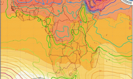
The Week’s Weather up to Friday 21 April Five-day outlook to Wednesday 26 April
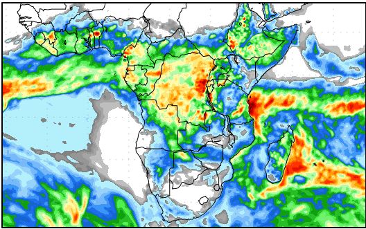
Precipitation forecast from Friday 21 April to Saturday 29 April
Source: wxmaps.org, GrADS/COLA
A rather extraordinary weather week for southern Africa. At the beginning of the week, a high pressure cell has wrapped itself around the southern Cape, the core barely remaining offshore. In the wake of the frontal system preceding the high, a substantial low pressure system developed, morphing into a proper vortex as the week progressed.
It is notable that the vortex remained in situ some 500 km south of Madagascar, blocking the eastward movement of the high around the continent’s southern extremity. This brought cold, windy conditions to the southern Cape, which later in the week actually reached as far inland as Namibia. This proved to be quite a substantial weather anomaly. It is very seldom that cold anarctic air reaches Namibia through the upper levels of the atmosphere but this is what happened.
Although on synoptic maps, the vortex looked similar to a depression or cyclone, it was the remnant of the frontal system. But being a low pressure system, it had a high vertical velocity, taking the cold air all the way up to above 18,000 feet. From there it was captured by the high’s leading edge, transporting it across South Africa into Botswana and Namibia. The result was chilly nights, but with the big difference that the cold came from above and not along the surface as would be the typical winter pattern.
Meanwhile, another low pressure system slowly developed offshore Walvis Bay with a marked but weak cyclonic circulation. This system had its biggest impact at the 500 mB surface, acting as a large rotating scoop that advected the air over the interior into the southern Namib and slightly out to sea.
Essentially, three different, systems all came together to produce a very unique sequence of weather events. The first was the vortex south of Madagascar, the second the low pressure rotation offshore Walvis Bay and the third, the typical surface inflow of warm, moist air from the northern half of the Mozambican Channel.
The zones where these three systems converged produced very active, unstable pockets that produced rainfall across very large parts of the country, including the Namib. Many of the recorded falls were surprisingly high while the bias remained over Namibia’s western half. The exception was Bwabwata and Zambezi where extensive rain occurred for three consecutive days.
What’s Coming
By the end of the week, the vortex has finally dissipated moving eastward and southward beyond Madagascar. The next approaching South Atlantic high pressure cell arrives on Saturday but the core, at a typical 1024 mB, remains offshore. The outer rim at 1016 mB penetrates South Africa up to the Limpopo Province on Sunday, moving further north into Zimbabwe by Monday.
This high pressure control over the eastern half of the sub-continent produces a typical late summer / early winter synoptic development over Namibia. The high pressure control on the surface leads to a strong anti-cyclonic circulation over southern Africa meaning that Namibia, located west of the core, will see a steady airflow from the north-east, turning due north early next week.
By Tuesday a strong differential exists between the high pressure in the east, and a substantial low pressure system over Namibia’s coastal plain in the west. This pressure differential creates the ideal conditions for strong Oosweer, which should impact the entire length of the coastline on Tuesday and Wednesday.
Positive rainfall conditions are indicated for almost the entire country over the weekend but the falls will be light. As from Monday, only sporadic rainfall may occur over the central interior.
There is a limited possibility of another cut-off low developing next week offshore between Oranjemund and Saldanha Bay. If this happens, it will do the same as this week, i.e. draw in warmer, moist air from the north-east which may just lead to a suprising final act in this year’s rainfall season.


