


Weekly weather overview and short-term outlook to Wednesday 23 January 2019
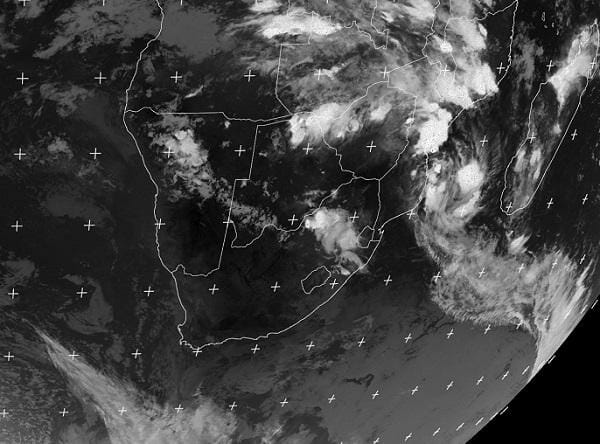
Visual: Infrared image of southern Africa from the Eumetsat weather satellite situated over the Prime Meridian. The image was composed late on Thursday evening 17 January 2019.
Source: Eumetsat, http://oiswww.eumetsat.org/IPPS/html/MSG/IMAGERY/IR039/BW/SOUTHERNAFRICA/
Recent Developments
This week turned out to be a fairly regular mid-summer weather week with a fresh intrusion of moisture from Angola and Zambia, but reciprocated strongly by the South Atlantic high pressure cell.
During the days, much cloud was visible across most of the country north of Rehoboth, but in the late afternoons, very hot conditions indicated high pressure control in the upper atmosphere.
A weak trough was present skew across Namibia from Angola to South Africa, shifting marginally to the west as the core of the South Atlantic high drifted southward on its way to pass the continent at Cape Agulhas.
The week’s four main features can all be seen clearly in the visual. The first and second are two prominent low pressure systems, one over the Mozambican Channel and the other about 2000 km south of Cape Town. The triangular white streak in the bottom left corner is the northern extension of an approaching front of which the southern terminal forms the second vortex.
Number three is the broad white band south of Madagascar on the right hand side of the image. This is the northern rim of the southern Indian high pressure cell where it encounters the tropical air of the Indian Ocean.
Finally, feature number four is the weak trough over Namibia and southern Botswana extending into South Africa. North-east of this trough is alto level high pressure control, originating from the south-east, and south-west of the trough is surface level high pressure control originating from the close position of the South Atlantic high. These areas are both dark.
In short, the week’s conditions can be summarised as high pressure control in the west and low pressure control in the east.
Of course, the overall synopsis is not that simple but the visual is a good snapshot of general conditions.
Since we are now at the beginning of the second half of summer, southern Africa’s topography will play an increasingly large role in how the weather develops over the next two months. The most important element is the shape and extent of the Kalahari basin, covering most of Botswana, the east of Namibia, south-eastern Angola, Western Zambia and north central South Africa.
This flat expanse of sand sits relatively far away from either ocean and is subject to large temperature fluctuations from night to day, acting as a pivot around which the rest of the subcontinent’s weather develops. Depending on the daily strengths of the so-called heat-low that forms over the Kalahari every day, it can influence Namibian rainfall conditions in both a positive and a negative way.
On the Radar
During Saturday and Sunday, low pressure conditions remain dominant in the Mozambican Channel but the leading edge of the South Atlantic high pushes around the continent without actually making landfall. The 1016 mB isobar remains offshore. By Sunday evening the high has shifted sufficiently to the east (at the bottom end of the Mozambican Channel) to open a short window of moisture to intrude into Namibia from Angola.
This will lead to the now-familiar pattern of much visible cloudiness but only very erratic, widely dispersed showers for the whole country south of Otavi. It is only from Etosha further north and in the north-eastern quadrant that there is a reasonable expectation for rain, – sparse in the north central areas, but more prolific in Bwabwata and the Caprivi.
From Monday to Wednesday there will be a repeat of the weak trough from Angola through Namibia into South Africa, but the bias will be in the west with the strongest possibility for rain in Kunene and Erongo on Tuesday, nothing spectacular however.
Nevertheless, with a trough over the interior, an airflow from north to south, and the heat-low in the east (over Botswana) it can literally rain anywhere if local conditions develop in such a way that there is sufficient cloud built-up. This excludes the central and southern Namib though.
As of Wednesday, rainfall conditions over the interior deteriorate with only a very small chance for some precipitation in the south-east (Hardap and Karas).
Overall conditions remain high pressure in the west, low pressure in the east. This is not conducive for local rainfall.


