


Overview for the week and 5-day outlook to Wednesday 21 March
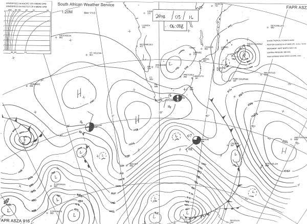
Visual 1: Synoptic map, surface conditions, southern Africa, Friday 16 March at 06:00.
Source: South African Weather Service, http://www.weathersa.co.za/observations/synoptic-charts
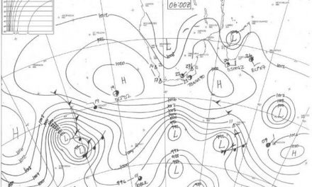
Visual 2: Satellite image of southern Africa, Friday16 March at 16:00
Source: South African Weather Services on Twitter
What Happened
Tropical storm Eliakim that is now hugging the north-eastern section of Madagascar again has a major impact on local weather despite being so far removed from Namibia. As its predecessor of ten days ago, it is draining moisture from central Africa and offshore East Africa but at the same time it is putting it back in the alto levels from where the northern rim of the south Atlantic high picks it up and brings it across the Mozambican Channel back to the continent.
These air movements are both zonal meaning that the airflow from Africa to the core of the vortex is roughly west to east while on its southern rim it is the opposite direction, from east to west.
Except for this gradually growing atmospheric disturbance, the rest of the sub-continent has displayed a fairly regular late-summer pattern.
During the week, two cold front briefly moved across the southern Cape. This was the first fronts this season to actually move across the mainland. On Friday morning’s synoptic map, the departing second front can still be seen offshore the Eastern Cape but with minimal impact on the western section of the sub-continent.
As is usual, ahead of the cold front the airflow is from north to south and behind it, from south to north. When the cold front has passed the Mozambican Channel, the airflow behind it pushes up the channel and it is then that this south to north airflow has a strong influence on Namibian weather. When it couples with a depression north of it, it advects moisture over the continent, entering at Mozambique, crossing Zimbabwe and Zambia into southern Angola and curves back over Namibia, bringing in what is left of that moisture.
On the second visual, this effect is more noticeable. This shot, taken some 10 hours after compilation of the synoptic chart, shows a well-demarcated convergence line running skew across Namibia from the Kunene in the north-west to more or less Buitepos in the east. Typically, convection is enhanced north and east of this line while suppressed west and south of this line. This does not mean that it can not rain west of this line but when it does, falls are isolated and sporadic.

The impact of Eliakim has not developed optimally. As it moved across Madagascar it decayed for about 24 hours before regathering once it moved back over the ocean. It still has much potential to be the origin of moisture for southern Africa, especially if it links up with the airflow behind the cold front.
This week, the general rainfall picture disappointed again. While there were some promising systems concentrated in the north-east and the central areas, falls were sporadic. Windhoek provides a prime example where it rained 22 mm in Akademia on Wednesday with the rest of the city only getting between 6 and 8 mm. For the rest of the country, the picture was very similar. Some good falls were reported from the central area north of Windhoek but these were isolated. In all these instances, only a few kilometres away, farmers reported only drops.
What’s Coming
Eliakim is still the feature to watch. There is potential that it will couple with the leading rim of the South Atlantic high as described above, but it is not a given. Moisture levels south of the Orange River are generally depleted while the regions north of the Namibia Angola border enjoy enhanced moisture levels.
During the weekend, the airflow over Namibia remains northerly to north-westerly. Airflow over the sub-continent is anti-cyclonic and is augmented by the northern rim of the South Atlantic high as it passes the Eastern Cape.
The rainfall outlook expects rain over the northern half of the country starting on Saturday afternoon. Depending on the strength and relative position of Eliakim, there is still an outside chance that the northern half of Namibia can see a 3-day rain window on Sunday, Monday and Tuesday but by Wednesday the vortex is too far away to contribute much to the local scene.
However its legacy is the moisture already present over the mainland and with the signature mid-level trough from south-western Angola across Namibia into Botswana and South Africa present from around Tuesday, there is a good chance of the rainy weather spreading both west and south.


