


The Week’s Weather up to Friday 04 August. Five-day outlook to Wednesday 09 August
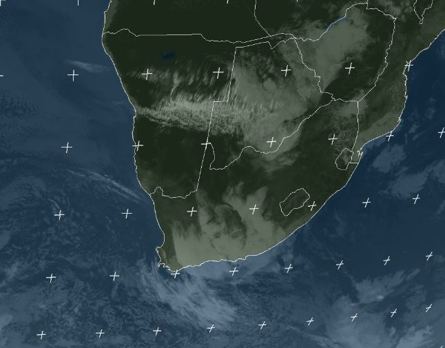
Satellite image: Infrared view of Southern Africa at 11:00 CAT, Friday 04 August 2017, taken from a position over 0° longtitude. Source: Eumetsat
An intricate system of high pressure cells controlled local conditions for the duration of the week. Early in the week, the South Atlantic high made landfall between Oranjemund and Saldanha Bay, slowly migrating across southern Africa from west to east. The southern Indian high was more or less stationary south-east of Madagascar although its core, at a strong 1028 mB, was displaced northward by about 600 km.
By the end of the week, the southern Indian high has moved very little while high pressure conditions took hold of the continent and the southern half of the Mozambican Channel. This resulted in a contiguous high stretching from halfway out in the Atlantic around the southern African coastline across the ocean south of Madagascar, and on to almost halfway to Australia.
When these massive, elongated, contiguous highs form, they restrict any significant north south and south to north airflow. The usual mechanisms for propulsion, the leading and trailing edges of high pressure cells, are consequently absent.
The flow of warmer, moist air from the north is inhibited while the typical cold antarctic intrusions are prevented from making landfall. These expansive highs are not unique, they are fairly typical of the terminal phase of the winter before the equinox in September.
On a local front, the weather was not as placid as the bigger picture. While the high sits over southern Africa, it causes an anti-cyclonic circulation advecting air from the Mozambican Channel across Zimbabwe, Botswana, Zambia and Angola into Namibia. This air has travelled about 3000 kilomtres over land, and with more than 11 hours sunshine per day, when it reached us, it is substantially warmer and lighter than the air immediately situated above the Namibian surface.
The latter originates from the South Atlantic high. Due to Namibia’s general proximity to the Atlantic, it means the air layer on the surface is significantly colder and denser than the air in the middle layers coming from the north east. Where the two systems meet the lighter air flows over the colder air and a so-called convergence zone forms.
Usually these zones are restricted to a few hundred kilometres but this week a whole convergence “province” developed, as can be seen on Friday morning’s satellite image. Earlier in the week on Wednesday, the convergence was visible as a few high clouds over the Namibian interior but two days later, the conflict between the two systems has intensified to such an extent that a large area became covered in cloud.
While no confirmation for light rain between Hosea Kutako and Buitepos was received, satellite imagery showed that there was definitely a chance of rain in a broad band from around Hochfeldt to Summerdown, to Drimiopsis and on across the border to Gantzi. Cloud tops at one point reached about 45,000 feet which is sufficient for denser cloud formation in the upper levels.
However, it is also more than likely that, like usually happens in September, virga rain falls aloft but is dissipated by the high on the surface, so not a drop reaches the earth.
What’s Coming
The important feature to watch for the next two months is the position of the core of the cyclonic circulation over the Indian Ocean. This core has been situated north of the equator for the better part of two months. In the last week, it has shifted southward and is now a whisker south of the equator. If it moves further south, it will amplify the so-called Indian Ocean transport and Namibia will have an above-normal early rain season.
Locally, high pressure control remains in place during the weekend and on through Monday and Tuesday. The biggest impact, however, is south of the Orange River so very little will change in Namibian weather.
It is only by Wednesday that the high pressure control is broken by an approaching frontal system but it is weak and the only expected impact will be in the southern Cape.
In general, static conditions are expected for the whole country for the next five days.


