


Overview for the week and 5-day outlook to Wednesday 31 January 2018
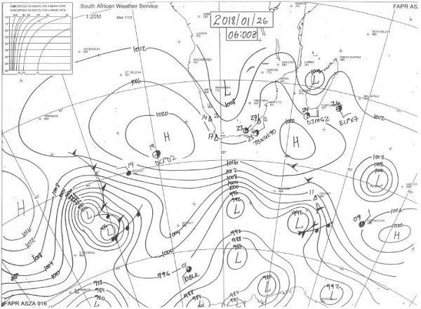
Visual: Synoptic Map of southern Africa at 06:00 on Friday 26 January 2018
Source: http://www.weathersa.co.za/observations/synoptic-charts
What Happened
Extensive cloud cover over large swathes of southern Africa was the most visible weather feature of the week. However, the cloud layers, although complex in a few local spots, suffered from one universal drawback – a lack of height.
The local scene was dominated by a fairly high cloud base between 12,000 and 16,000 feet depending on the strength of the South Atlantic high pressure cell. As can be seen on the synoptic may above, the high’s core has shifted south by a good 600 km and weakened by 4 mB. Both these developments are good signs but it is premature to premise the rest of the rain season on the short-term movement of one week only. The centre of the core is now almost back to its usual position around 1000 km west of Cape Town.
On the eastern side of the synoptic map, the southern Indian high is also in its customary position and of the same strength as its South Atlantic counterpart. Between the two cores, an extended high pressure zone wraps around the southern Cape measuring 1016 mB which constitutes more ore less the outer rim of both highs. Over land, lower pressures are present ranging between 1012 mB and 1008 mB. The extensive upper air ridging that was a prominent feature of the past four weeks, has also subsided, with far more movement in the upper layers as witnessed during this week. The absence of large areas of ridging indicates a weakening of high pressure control in the upper air. On the surface, it is seen in the moderation of late afternoon temperatures.
Overall conditions for the whole subcontinent are changing rapidly to a more typical stance for the second half of the austral summer. The complexity and inherent mobility of the twice-daily synoptic maps begs for caution but the enduring feature over several days is the diminishing power of the high pressure cells, and consequently of their combined impact on the sub-continent from both east and west.
As the southern Indian high subsides, it boost the so-called Indian Ocean transport which also appeared more pronounced this week with a strong east to west zonal flow over northern Mozambique, Zimbabwe and Zambia. Coupled with the favourable position of the Inter-Tropical Convergence Zone, conditions are finally improving for larger volumes of moisture to move from north to south.
As could be seen from the cloud formation over most of Namibia except the southern Namib and the far south, ample moisture is present over very large areas of the country but it is captured in a so-called inversion layer where the difference in densities between the air masses from the south and the north suppress convection. So, although extensive cloudiness was visible, the cloud layer was flat, the base too high, and the tops severely restricted. When this happens, precipitation does occur but both the rainfall intensity and the total amount of precipitation are limited. It is only in a few isolated spots where some convection pushed through to the upper levels, that significant showers were recorded, most notably in the areas south of Tsumeb, and surprisingly on the Botswana border in the Otjozondjupa region.
What’s Coming
The southern Indian high weakens during the weekend, opening the gateway for lower pressures to develop over the western half of southern Africa. The weakening high also leads to a consolidation of the upper atmosphere over east Africa, generally allowing more moisture with a considerable depth to enter central Africa.
Rainfall activity continues over the northern half of Namibia but convection is still suppressed meaning that shower potential is limited despite the extensive cloud cover.
A weak mid-level trough is present from Angola through Namibia’s north-eastern quadrant into Botswana. The consensus outlook is for this trough to gradually shift to the east, taking the rain with it, but as always with Namibia’s almost unpredictable weather, this system may just as well develop to the west. This will lead to some pleasant surprises as the system has all the potential to move as far west as the escarpment and further south into the Hardap and Karas regions.


