Weather 31 July 2015
![]() What Happened
What Happened
A rare phenomenon manifested during the course of the week. Early in the week, the customary high pressure cell sat over South Africa causing a pronounced airflow from the north-east across the eastern half of Namibia.
This cell also drove the anti-cyclonic circulation over the entire sub-continent which was noticeable on the surface but the real action was at the 700mB level or just over 8000 feet above sea level.
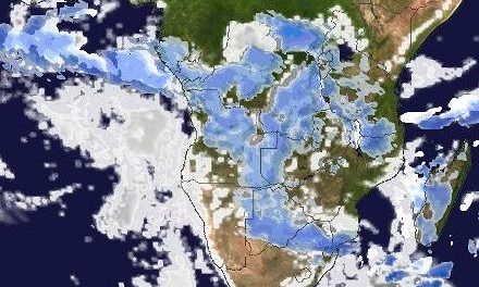
At this level, high pressure control was evident reaching as far north as Zambia and halfway into Angola. By Wednesday, a trough was developing on the surface, noticeable by the hazy horizon over most of the interior. But the core of the anti-cyclonic circulation at the 700mB level has shifted to southern Angola, creating a wide arc of middle layer air that left the continent at the Gabon coastline, penetrated deep into the Atlantic Ocean before recurving to the south-east. The rim of this massive circulation entered Namibian airspace over the northern Namib, becoming visible as a layer of cloud that rapidly moved from the Kunene towards the Kalahari.
A convergence line did not form on the surface, instead the direction of the airflow was mixed, indicating high pressure control on the surface. This was also witnessed by the relatively windless days, compared to the previous weekend, over the northern half and the central plateau. However, at 8000 feet aloft, a very prominent convergence line became visible through the appearance of substantial cloudiness. This band was driven by the southern rim of the middle level high pressure cell over southern Angola. It developed into a prominent trough by Wednesday despite the high pressure conditions on the surface.
With the high pressure cell over South Africa rooted and amplified by the southern rim of the South Atlantic high, the trough developed some depth, descending, and bringing even more cloudiness to the northern Namib, leading to very foggy conditions on Thursday.
The South Atlantic high was fairly strong but the core, measuring some 1034mB remained far offshore, only sending out a weaker extension which crossed the Karas Region, leading again to cold conditions on the surface with some cloudiness that originated from the extra-ordinary circulation off the Angolan coastline. In the upper air however, where the Angolan system met the upper extent of the South Atlantic high, the two opposing systems created an exceptionally strong zonal flow from west to east. It is this airflow which quickly moved the cold on the surface level towards the east. Again, this could be seen by the fast return of warmer weather in the Karas Region by Friday, with only a lingering over the Kalahari and the Botswana border as the high pressure cell migrated towards the east.
The Angolan circulation reached the southern Namib late on Wednesday, there also leading to some low level cloudiness and if there were any humans in the Sperrgebiet, we may have received reports of light rain.
The winter rainfall season over the so-called succulent Karoo has to date been spectacular. Namibians who have not yet witnessed the explosion of flowers in Namaqualand in South Africa’s Northern Cape province, will not be disappointed if they visit this area late August, early September.
What’s Coming
The cold intrusion in the Karas Region and along the Botswana border has all but cleared by Friday night. The west wind is quickly replaced by airflow from the east, backing to north-east during Saturday and continuing on Sunday. This warmer airflow covers the entire country, restoring daytime temperatures resulting in a pleasant weekend. The only exception is the southern escarpment, and the adjacent southern Namib where windy conditions will prevail but with the wind direction mainly north-east to northerly.
By Monday, the wind direction has become prominently northerly with only the Zambezi region seeing airflow from the east. A strong vortex forms some 1500 km west of Cape Town and may even develop into a so-called cut-off low. The leading edge of this low pressure system enhances the airflow from north to south, bringing warmer temperatures to the entire country. It may again bring cloudiness to the interior and to the Karas Region later into next week.