Understanding Weather – not predicting -7 June 2013
What happened?
A quite rapid set of mobile synoptics was to be seen just about world-wide, this was not just unique to the Namibian scene. Yet there was a level of consistency in that the mobility revolved around a pattern associated with our geography.
An anticyclonic core floating above the eastern sub-continent was the controlling feature: more-or-less consistent with normality. As such, it ensured a northerly airflow throughout the lower and middle levels. This set of synoptics links and contributes to the active patterns created by warmer airflows being guided southward, so ensuring vortex development when meeting to override the colder air that originates over the Atlantic.
This turbulent mass with cold air surging northward undercuts the warm air. This is normal, but it has its own ranges of variability which were manifest during these past few days.
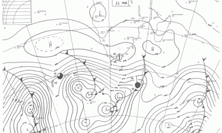
A week ago,the outlook saw a well-developed trough approaching from the west, extending into our south. Behind, cold air would drive the trough eastward by midweek when a new vortex would appear. In the cold, unstable air one new trough and vortex appeared as the old front crossed our far south, but this new core weakened the first one. There was no high pressure advance, while yet another secondary trough built behind, another frontal collapse, while in the upper air west of Namibia a major trough formed, evolving into a clearly marked cut-off vortex. This wavered, its prognoses varied across the week.
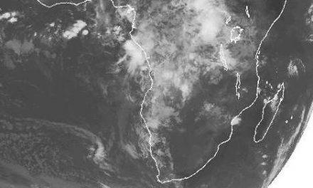
The result was that the brief winter intrusion of last Sunday was quickly expelled when the airflow reverted to north, bringing warmer air from Angola to cover the entire Namibia. Except for the brief early morning cold, the days were unseasonally warm even reaching the upper twenties north of Otjiwarongo.
What’s coming?
While the current vortex area moves away, an anticyclonic ridge (high pressure) squeezes across the southern Cape eventually building into a substantial core to the east by Monday. This keeps the airflow north throughout and the complementary west coast trough persisting. Northern Namibia remains hot by day (30oC), central parts remain warm by day but clear skies provide for maximum radiation, local inversion sees temperatures only recovering once early morning sunshine breaks this down.
Southern Namibia returns to daytime warmth. The next major trough appears (once again) clearly in the middle layers by mid-week west of the Cape.
Whether or not this is complementary remains to be seen, but the Indian Monsoon and the cooling surface waters of the eastern Equatorial Pacific, both with a favourable ring for future developments, continue their evolution. Another semi-link sees recurrent surface anticyclonic cores making their way in southerly latitudes (+-40oS) pushing both vortex cores and their troughs to the north (Cape coast) with cut-off potential. The wind at the coast will be mostly from the north.