Understanding Weather – not predicting – 02 August 2013
What happened?
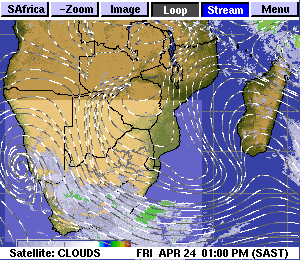
The probability of a cold intrusion was fully met as the flow behind a cold front swept, perhaps obliquely, across much of Namibia. The oblique feature saw the brunt of the inflow swirling in from the southeast rather than the southwest or even south. This departure from our expected source meant that the harshest impact was limited both in duration and temperature. Still the cold gave some overnight frost coupled with limited daytime temperatures for the central and southern upland interior (meaning maxima below the 20oC mark). Temperatures in the south struggled to reach 15oC for the two key days marking this episode.
The initial thrust of the cold air brought a thin cloud layer into our far southwest. Some orographic uplift even squeezed a few raindrops for the most exposed parts of the escarpment.
The rapid thrust of the entire synoptic pattern together with an intensification of the anticylonic core saw wind-flows back from southeasterly to east or northeast by Wednesday which established a similar flow (westward) across the coast.. While interior minimum temperatures hovered just above zero, coastal minima were warmer than the daytime maxima for our southern interior: minima of 18 to 20oC or more compared to maxima between 15 and 18oC. The coast experienced the wind, warmth and dust of the oosweer with maxima readily up to the 30oC.
As the whole pattern proceeded, a moist lower level air flow swept across the eastern continent and was bold enough to penetrate our northeast (mid continent), spreading a cloud layer with an active, convective response across northern and central Namibia. Nothing startling, perhaps, but still by July standards, exhibiting the unusual for our selves.
Like so many features of weather, this is interestingly complex, again.
What we are coming to terms with is that with the presence of a changing climate, the patterns previously described are now scarce.
Had this last week’s synoptics occurred in summer, a wet story would surely have evolved.
What’s coming?
Extreme weather ranges across the southern oceans seem to have eased to more normal values. The dominant anticyclone persists during the weekend, by which time it weakens as it departs eastward. But the easterly flow pattern holds sway into mid-week. One cold front falters, but the second is expected to form an upper trough to the west over the Atlantic Ocean. Further development is speculative at this time range, so frequently promising patterns form but dwindle as they approach the sub-continent. But the “cut-off” vortex season is on our doorstep. Cut-off vortices are the stuff our rain season depends on so do not be surprised when we see early rain in August.