


Weather overview and short-term outlook to Wednesday 10 February 2021
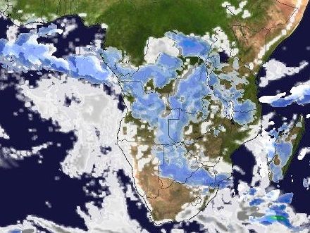
Visual: Inferred rainfall for central and southern Africa as on Friday 05 February at 14:00.
Source: Meteoblue.com, ultimately based on data provided by the National Oceanic and Atmospheric Administration (NOAA) of the US Government. www.meteoblue.com/en/weather/map/precipitation/africa
Recent Developments.
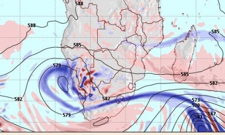
Over the past fortnight, it was noticeable that the bigger elements, especially in the middle layers around 18,000 feet, have made a gradual but persistent shift to limited high pressure control. This is most readily visible in the 500 mB maps where the 588 decametre line has been hovering over Namibia often.
Conditions in the middle and upper atmospheric layers are extremely sensitive to minute changes in pressure and temperature. For this reason, when the 500 mB surface sits 5880 metres above the ground, the atmosphere is slightly thicker, and convection is suppressed. This is a very mild form of high pressure control in the middle layers.
When the 500 mB surface descends just 30 metres to 5850 metres above ground level, there is already a noticeable change in conditions, convection is enhanced and chances for local rain are more positive. This gives one an idea of the importance of accurate observation and measurement in meteorology, especially how it relates to forecasts.
Given Namibia’s topography and abundance of solar energy, it is unreasonable to assume the various measurement surfaces will stay at a particular elevation for a long time. Indeed, they do not and it is a signature of Namibian weather that large oscillations occur between day and night, between early morning and late afternoon, and between summer and winter.
In short, our weather is basically unpredictable when compared to the moderate zones of the world. The instability and volatility is just too big to issue any meaningful forecast beyond 48 hours.
This week’s visual was chosen specifically because it shows rainfall probability as inferred and interpreted by a sophisticated computer programme, based on telemetry received from weather satellites. Now it must be remembered that most weather satellites do not take pictures, they measure wavelengths and from these the computer concocts a picture which it deems to portray actual conditions closely. So even “pictures” of clouds, are not entirely foolproof.
Nevertheless, the visual shows that the most active regions run in a very large arch from the Mozambican Channel through northern Mozambique, southern Tanzania, Malawi, the south-eastern DRC, Zambia and eastern Angola. Upon closer inspection, one can also discern the open spot over central Mozambique and then of course, the open areas over southern Namibia and the South African interior where the South Atlantic high pressure cell is pushing back the moisture from central Africa.
What is important in this visual is that it provides clear evidence that the strong surface obstruction that was present in 2019 over western Tanzania, has given way during 2020 for a strong infeed from the Indian Ocean. In other words, the conventional summer moisture route for Namibia is basically intact. We can expect much more from this season. We must just realise that actual rainfall will be determined by the relative position of the South Atlantic high. From the north, there are no impediments for a good summer rain season to continue.
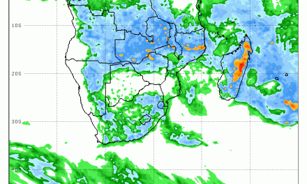
On the Radar
For the next few days, conditions remain static with little intrusion from the north.
Three forecasts are unanimous that rainfall activity will only be present over the north-eastern quadrant although it must be observed that two of them indicate daily cloud formation right up to edge of the escarpment.
In general, rainfall prospects are not very positive for the first half of February.
One feature to watch however, is the persistent cells that keep developing over central Botswana. This can be seen at the bottom of the sidebar on this page which shows actual rainfall and not cloud formation.
The strong rains of January were also preceded by two weeks of cell formation over eastern and central Botswana.


