Weather 17 July 2015
What Happened
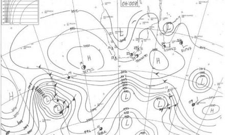
The synoptic map, as it progressed from Monday to Friday, remained in the grip of a complex set of winter elements.
The South Atlantic high pressure cell has been hugging the African coastline the entire week, making landfall on Wednesday, leading to very cold conditions in the Karas Region, then slowly circling to the east, bringing cold nights to the Botswana border and adjacent areas.
This cold intrusion penetrated far north during Thursday and Friday, dropping nighttime temperatures to around 5oC as far north as the Kunene and the Otjikoto Regions. It was only in Kavango East and the Zambezi where night temperatures did not go below 10oC. Over the entire country, the cold came from the south-west and then directly from the south. It was only later in the week that the intrusion switched direction to south-east and then east, indicating the presence of the migrating high pressure cell over South Africa.
The synoptic complexity was indicated by a relatively strong trough (low pressure band) flowing from north to south ahead of the cold front. Where this system met the outer rim of the high pressure cell, a very prominent convergence line formed along the Orange River valley. The Karas region, being in closest proximity to this imaginary line, saw cold and overcast conditions on Monday and Tuesday, which repeated on Friday, but with less intensity and less cloudiness.
By Thursday, three powerful high pressure cells dominated local weather and this was set to continue through the weekend, reaching a climax on Monday night. The South Atlantic high measured 1032 mB, the continental high about 1028 mB and the southern Indian high, then some 1000 km south of Madagascar, checked in at an impressive 1024 mB. This combination shows that the entire southern African sub-continent is in the grip of a strong July winter pattern.
El Nino update
The Climate Prediction Center in the National Oceanic and Atmospheric Administration (NOAA), resorting under the US Department of Commerce, in their latest El Nino update released on Monday, said El Niño conditions are present over most of the Pacific Ocean. “Positive equatorial sea surface temperature (SST) anomalies continue across most of the Pacific Ocean. There is a greater than 90% chance that El Niño will continue through the Northern Hemisphere winter 2015-16, and around an 80% chance it will last through early spring 2016” (Northern Hemisphere). “During September-December 2014, positive SST anomalies covered most of the equatorial Pacific. During January through mid-March 2015, near-to-below average SSTs were observed in the eastern Pacific, and positive SST anomalies persisted across the western and central Pacific. During the last three months, positive SST anomalies strengthened across the eastern Pacific.” This week the surface temperature anomalies ranged from 1.1ºC near Indonesia to 3.3ºC off the coast of Ecuador.
What’s Coming
In sixteen days, the sunshine hours per day at the Windhoek latitude will pass 11 hours. This is broadly an indication when daily solar energy exceeds a critical energy threshold, leading to progressively warmer days. It is also the end of July and is usually the time when a noticeable transition takes place from a winter pattern to an early summer pattern. This weekend will remain cold in the south-western quadrant. South of the line that intersects Walvis Bay, through Mariental to Mata Mata, there is certainly a chance of nighttime temperatures going to zero or even below zero on the inland plateau of the Karas and Hardap regions. A second cold front arrives on Sunday, spills over into the rest of the country by Monday, and will lead to zero or below, as far north as Windhoek. As the high shifts to the east, the cold will come from the east from Tuesday onwards, and should affect the Gobabis district and the Kalahari most. Again, a trough running from north to south just ahead of this cold front, will bring cloudy conditions to Khomas, Hardap and Karas but with very little expectation for precipitation.
From Tuesday onwards, high pressure (cold) conditions over the eastern half of the country is offset by lower pressure over the Kunene region where windy and dusty conditions should be prevalent over the northern Namib.