


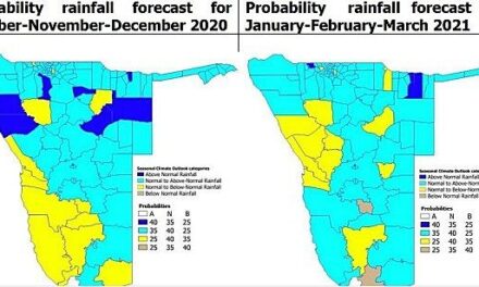
Weekly weather overview to 08 July and short-term outlook to 12 July 2019

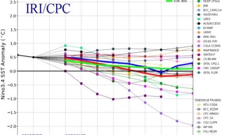
Visual: Sunspot cycle forecast by Eurico Covas, Nuno Peixinho and João Fernandes of the University of Coimbra.
Source: spaceweathernews.com. Full article can be requested here: www.researchgate.net/publication/322517764_Neural_network_forecast_of_the_sunspot_diagram
Recent Developments
With nothing eventful happening on the local scene, it provides an opportunity to discuss weather aspects that do not often feature in mainstream science.
For the past thirty years, a few scientists have noticed certain synchronicities between solar activity and previously unexplained, or poorly understood, weather patterns. Checking sun activity data back to when it was first collected, a discernible pattern of regular suncycles has emerged, based on the number of sunspots on the surface of the sun, and so-called Coronal Mass Ejections (CMEs), more popularly known as flares.
It has been established that the suncycles follow a fairly regular pattern of approximately eleven years. Over the past forty years, it has also been determined that the cycles have become progressively weaker, i.e. the number of sunspots (as a proxy for overall solar activity) has steadily declined. Concurrently, it has transpired that the very regular weather patterns have been upset and that it has become more difficult by the year to issue reliable weather forecasts. The older (outdated) data simply does not support the methodology to make provision for the significant weather changes which has been happening over the last thirty years or so.
If everything in the solar weather nexus has become so unreliable, one can ask the valid question, what is the significance of all of this particularly for us in Namibia.
This week’s visual provides at least some of the answers. Looking at the years at the bottom of the image and the gradient of the cycle, there is a weak correlation between the upward phase of the cycle, and wetter spells in Namibia.
There is very little academic work on this relationship but any person can compare the years to his or her own rainfall notes. It then becomes clear that the first half of the cycle tends to favour a five to six year wetter period, followed by a six to five year drier period.
The forecast for the 25th cycle, due to begin later this year, or early next year, is based on the regular eleven year period, albeit a much reduced cycle. What the impact on Namibia will be with such a weak suncycle is not known and whether the broad notion of wetter and drier cycles will be repeated with the new cycle, remains to be seen. It is not even 100% sure that the next suncycle will indeed be weaker.
The relationship between the sun and earth’s weather is not nearly as simple as this brief discussion. There are many elements, the effect of which is only now being noticed. For instance, the sun’s magnetic activity has a distinct influence on the earth’s so-called magnetosphere but the science is still only at the observation stage. Exactly what the dynamics or the physics are, is not yet known.
On the Radar
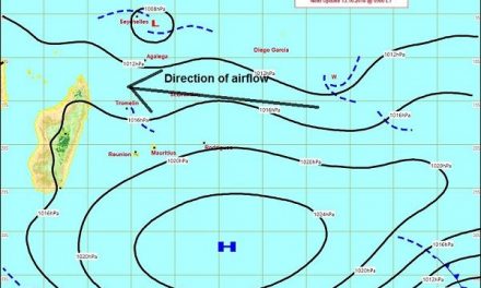
Static winter conditions continue over the entire country until Thursday when there is some minor instability in the mid-level atmosphere over the northern half. There is no sign of a mid-level trough, or a frontal system at the Cape for at least another three days.
Barometric pressure over the interior (east of the escarpment) remains relatively high ranging between 1024mB and 1020mB. These are standard winter pressures.
There is a significant pressure differential between the interior (Namibia and Botswana) and the coast indicating that the airflow over the interior from north to south, will be north-easterly to northerly but easterly on the coastal plain.
This indicates that a weak form of Oosweer will be present over the coastal plain (west of the escarpment) but the effect will fizzle out about 30 km before the actual coastline.
The next approaching South Atlantic high is present by Friday evening, but the effect will be limited to south of the Orange River with a slight chance that there will be windy, cold conditions in Oranjemund, Lüderitz and Aus.
Although the nights will be cold, frost is not expected for this week.


