21 November 2014
![]() What Happened?
What Happened?
High pressure control on the surface as well as in the upper layers, remains the order of the day.
The weather stance at the beginning of the week was fairly conventional, except for a marked low pressure depression over the Kunene region.
In the South Atlantic, the core of the resident high pressure cell moved about 1000km south as it traversed the southern Cape. This southward move increased its strength as it entered an area of cooler sea surface temperatures. The high pressure cell over the southern Indian Ocean remained more or less on the same latitude as last week, and also relatively weak, or at least noticeably weaker than the South Atlantic high pressure cell.
But between these two high pressure cores lay a very significant vortex with its core some 2000 km south of Madagascar. This vortex had and continues to have a major impact on local weather.
On the surface, the approach of the South Atlantic high is readily observed. Strong south-westerly winds in Lüderitz always provide the first clue of its arrival. These winds then back to south over a period of two to three days, as happened this week. The effect in the interior is much colder than expected night temperatures covering much of the southern half of the country. Later in the week, the windflow switched from south-east to north-east, as expected, leading to the formation of a very weak trough along the convergence line that splits the country into two halves, from Ruacana to Aroab. However, the vortex south of Madagascar, has its most important impact, not on the surface but at the 700mB level, some 8000 feet above sea level.
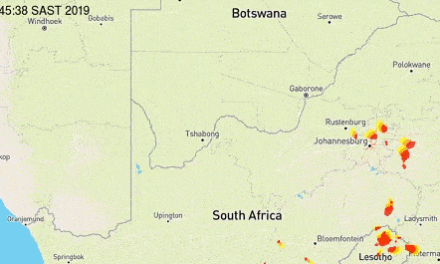
The airflow maps at this height show a very strong zonal channel flowing from west to east. This means the high pressure engine that is suppose to drive the anti-cyclonic circulation over the interior of southern Africa, becomes weakened and the resultant inflow of moisture from the Kongo and Angola, is severely restricted. It also creates high pressure control in the upper air over eastern Africa, obstructing the normal advection channels for moisture from the Indian Ocean to enter the continental airspace. It must be remembered the Indian Ocean is the primary source of moisture for the entire southern Africa, and when peculiar atmospheric conditions limit airflow from the east, the resultant decrease in precipitation is experienced over the entire subcontinent. Over Namibia, the airflow in the upper air, above 30,000 feet, continues to reflect a typical winter pattern. Flowing very strong from west to east, it drives whatever trough may develop, quickly towards the east. It also limits convection and when the cloud tops reach about 35,000 feet, they simply evaporates into the colder, denser, drier upper air. This was seen every day of this week. Only in the eastern-most districts in the Kavangos and the Zambezi, did some rainfall occur, but still very limited in intensity. Sporadic falls also occurred from western Etosha, south-eastward to the Kalahari.
What’s Coming?
The weekend starts with the South Atlantic high pressure cell wrapping around the southern continent from about Lüderitz all the way around to about Port St Johns in the Eastern Cape. This presence effectively block the southward extent of the very weak trough that forms daily from Angola and across Namibia.
The so-called heat-low over the interior, is relatively week due to the same conditions that persisted during the week. (See above). The coastline experience mild wind from the west, turning south-west by Sunday while the interior remains mostly clear and sunny.
By next week, the heat-low grows in intensity with its core over central Botswana. It will be very hot at this core area spreading out to the Zambezi in the north, and to the eastern districts of the Otjozondjupa and Omaheke regions near the Botswana border.
However, west of this hot area, a weak trough remains in situ between 15,000 and 30,000 feet. This advects limited moisture over the interior leading to very isolated showers of low intensity along the convergence line. These conditions remain more or less static for most of next week. Again, the exception is the Kunene region where the lower pressure area may produce some rain.