


Weekly weather overview and short-term outlook to Wednesday 23 October 2019
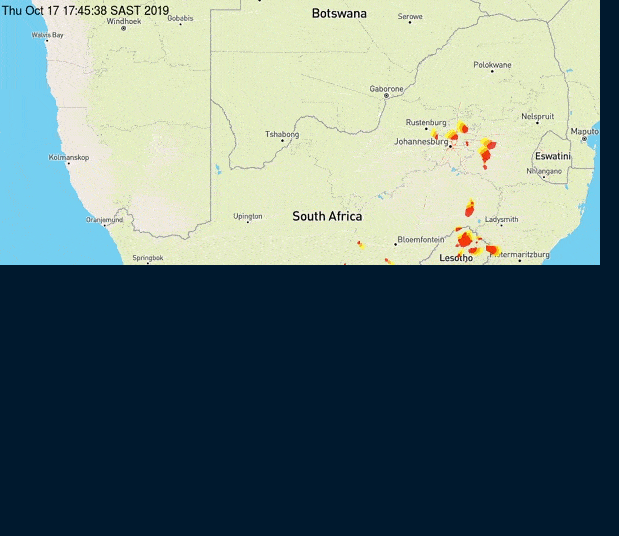
Visual 1. Recorded lightning over southern Africa for Thursday afternoon, 17 October.
Source: www.africaweather.com/pictures/maps/Lightnings/South%20Africa/South%20Africa/0000
Visual 2. Recorded lightning over southern Africa for Thursday afternoon, 17 October.
Source: South African Weather Service, https://sawx.co.za/storms-lightning/
Recent Developments
The two visuals show the stark difference between the observation efficiency of different weather monitors. The two images show lightning at more or less the same time, i.e. the three-hour period up to 18:00 on Thursday afternoon.
It is obvious that the official South African weather agency captured zero incidents of lightning in Namibia while africaweather captured a major system over the Karas and Hardap high ground above the escarpment with an extension into South Africa’s Northern Cape province.
The reasons for these conflicting observations can be many. It is not the scope of these weekly overviews to delve into the technical side of satellite observation and how images are processed from measurements that are basically recordings of either light or temperature, in other words, wavelengths. Still, the two images serve as an admonition that even weather data, especially on the visual side, must be handled with care.
This week’s weather presented a mixed bag of elements. Overall, the sub-continent enjoyed a week of mostly lower pressure with only some weak surface ridging in the eastern half. Low pressure conditions were indicated by the barometric pressure generally coming down to around 1012 mB from just before noon to about 16:00 in the afternoons. In Namibia, windy conditions, both during the day and at night, indicated lower pressures and fairly pronounced pressure differentials between the ocean and the land.
Both the southern Indian high and the South Atlantic high remained far offshore with the former weakening to 1020 mB but displaced to the north by about 400 km. The inshore South Atlantic high basically collapsed, pulling the core (still at 1024 mB) far offshore (about 2000 km) and displaced to the south, straddling 40°S.
Perhaps, the most important feature was the inability of the surface trough in the southern parts to link up with the mid-level trough over the northern third of Namibia. Nevertheless, there was some intrusion of tropical air in the mid-levels with ample vapour in the alto levels.
The absence of pervasive high pressure control in the upper atmosphere allowed for the first time this season a good measure of instability and convection leading to multiple lesser convergence zones forming more or less across the country from the north-west to the south-east. This convective action lead to many lightning storms in the convergence zones but the rainfall they produced were disappointing, measured in only a few millimetres and very scattered.
The relative weakness of the trough and the divergence between surface and alto conditions are what inhibited rainfall potential. Relative humidity was also on the low side failing to go above 30% over most of the Namibian interior.
On the radar
The South Atlantic high stays far offshore for the duration of the weekend. This allows the lower pressure conditions over the interior to grow in strength. It is only in the south that there is some ridging but not above 1016 mB.
The cloud base is somewhat elevated, also contributing to inhibit rainfall prospects. Although some cloud formation will continue in the interior, the critical mass is absent and it seems as if the skies will start clearing over the course of the weekend.
Not much is expected rain-wise but with lower pressure continuing over the sub-continent as a whole and over the western half of Namibia in particular, the mid-level trough may be more active than currently indicated. If this happens, sufficient moisture may enter Namibian airspace from Angola to produce clouds with convective potential. The bias will be over the western half in the north and again over the eastern half in the south.
The heat-low that is developing over northern Botswana will prevent any spectacular early-season developments over Bwabwata and the Caprivi in the Zambezi Region.
The outer rim of the next approaching South Atlantic high will impact conditions below the escarpment from Tuesday afternoon with considerably lower temperatures expected in the interior for Wednesday.


