Understanding weather – not predicting 01 November 2013
 What happened?
Whether we like it or not barely days go by without seeing front page headlines of some excess of actual weather: rain, temperature or wind either individually or in combination variously around the world. This usually leads to disaster.
The question is, when will it be our turn. The answer is that due to our geography such events are highly unlikely.
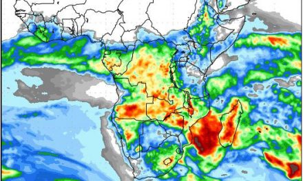
For instance, the South Atlantic is cool so it does not spawn tropical storms. Our altitude and consistency of the plateau restricts a further range of excessive weather events, not counting the general scarcity of water.
By world standards, Namibia’s climate and the day-to-day weather patterns are benign.
What worries us is the extreme variability of an arid climate. Our limited rainfall leads to headlines of drought, but also, too often of floods.
Perhaps not in headlines yet, but looming, is the persistent ability for rain-making patterns to appear to our south, but barely intrude our airspace . Or rainfall to the east never developing and spreading west to cover larger areas of the country.
At this point, we are a few weeks early for the essentials of a rain-making synoptic pattern to evolve and mature. The existing synoptics shows promising anticyclonic circulation over Angola and Zambia but still too far east at this time of year. The remains of the wintry style upper air core have not yet received enough convection to squeeze them away.
This week gave yet another sample of this overall synopsis. A major vortex came and went, south of the Orange, the succeeding ridge pushed in, departing with another vortex in place, same place, by mid week.
The moist band thinned somewhat above Botswana with rainfall restricted to mid-Angola or well away to our east. As these synoptics came and went the ability for cooler air flows persisted from the south for all but the extreme northeast.
Rain? Little better than occasional drops!
Typical mid-Spring weather? In many ways, yes: the dry burden of an Arid climate persists during the “difficult” months.
No rain was recorded anywhere by the Namibia Meteorological Service.
What’s coming?
The cut-off vortex close to Cape Town departs by weekend, again. The succeeding ridge, along 40oS lies southeast of the sub-continent by Monday. Its moist inflow is restricted to the eastern half: only distant lightning, for us, as November begins.
The moisture presence above mid-Angola and Zambia thickens. This is ahead of where the seasonal Inter-Tropical Convergence Zone should be by month-end.
Our rainy prospect is at best for only the far northeast. Sunny elsewhere, daytime temperatures hot, but not yet hot enough. But like much of the rest of the world, seasonal delay seems evident.