07 February 2014
![]() What Happened?
What Happened?
Generally a drier week than last week as seen in the recorded rainfall for the seven northern regions, but Omaheke is the glaring exception. Official rainfall data from Gobabis indicate rain on almost every day for the past seven days, but reports from the district indicate rainfall in excess of 150mm. Very heavy falls were also recorded in the Hereroland East and Bushmanland areas of Omaheke and Otjozondjupa regions respectively.
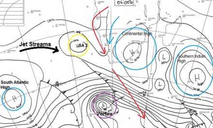
The synoptic pattern developed from a typical Atlantic High cum Interior Low during the weekend to a very complex pattern early this week. The high pressure cell of the South Atlantic was where it is supposed to be, with a prominent, dry influence on the western half of Namibia, leading to overall drier conditions.
However, a weak low pressure area formed in the southern part of the Mozambican Channel, in relatively close proximity to a secondary high pressure cell about 1000km south east of Madagascar. Two more, slightly stronger, low pressure cells developed due east of Madagascar, adding to the complexity of the airflow from the Indian Ocean, across central Africa, all the way down in a broad swathe to the central plateau of South Africa. Namibia, lying on the western fringe of this massive southward circulation, received rain in its eastern parts.
The combination of the migrating Atlantic High, the secondary high south of Madagascar, the weak low pressure cell, and the two prominent low pressure cells in the Indian Ocean lead to a strong zonal airflow from east to west entering the continent more or less over the Mozambique Tanzania border, covering the entire DRC and curving southward across Angola and Zambia. The main pathway crossed over Botswana, taking the moisture far south into South Africa.
In the upper layers, between 35,000 and 45,000 feet was a strong anti-cyclonic circulation with its core situated where the Sashi meets the Limpopo. This huge circulating wheel brought the moisture in the middle layers, present over western Zambia and Botswana, into Namibian airspace. Early in the week, this displacement of the equatorial low could be observed in the very low cloud base below 7000 feet. All in all, favourable conditions for the eastern half of Namibia.
By the end of the week, the upper level anti-cyclonic circulation has shifted to the east, present over central Botswana, but the influence of the approaching Atlantic High was too strong to allow significant westward expansion of the equatorial low.
What’s Coming?
As the Atlantic High follows its predetermined route from west to east over the weekend, it clears Namibian skies of moisture in all levels of the atmosphere but as it slips past the southern Cape, it again becomes the engine that drives the anti-cyclonic circulation over the subcontinent. Coupled with the continuing strong zonal flow from the Indian Ocean across central Africa, rainfall prospects improve again by Monday. Varying intensities are indicated for most of next week for most of the country.
A visible anomaly, (also present this week) is the influence of the Atlantic High over the central Angolan plateau. As the airmass above southern Africa rotates anti-clockwise, it advects moisture across Namibia but from the north east, i.e. the source is Zambia, and not central Angola as is customary this time of the year. The northern extremes of the South Atlantic High opposes the circulation from the Gulf of Guinea, leading to drier conditions in central Angola, with a marked impact on southward circulation. All forecasts indicate improved rainfall prospects for the entire country, starting on Monday and continuing throughout the week.