Weather 08 July 2016
What Happened
The week started with a return to warm conditions. While the nights were still cold, as expected, by Wednesday the days in the interior became pleasant in the afternoon. In the Kunene region and in Owamboland, it was even more pronounced with daytime temperatures almost touching 30° Celcius.
This is the effect of warmer air flowing from Angola as a result of the anti-cyclonic circulation of the high pressure system over the subcontinent.
It has been a feature of the winter so far that forecasts are downgraded the closer one gets to the event. What were seen as major cold spells, never fully materialised.
When the high is situated over South Africa, its has a leading edge on its eastern rim with the airflow from south to north. This is what brings this week’s unexpected winter rain to southern Mozambique and southern Zimbabwe. On its trailing edge on the western rim, the airflow is exactly the opposite, from north to south. This is what brings to Namibia a mild winter as the (expected) cold intrusion from the south is opposed by the warmer, lighter air from central Africa.
The continental high originates from the South Atlantic high pressure cell. It always approaches the continent from the west, then slips around Cape Agulhas and moves up the Mozambican Channel from where it curves back over the continent. It is this long journey of over 5000 km that provides ample opportunity for the cold air from the south to absorb solar energy and become warmer as it backtracks over the continent from east to west.
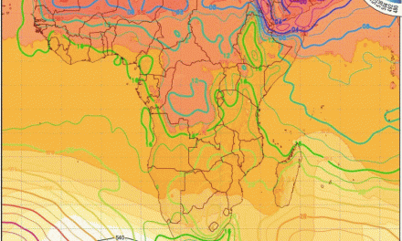
Typically, the high over the continent would be isolated from the next South Atlantic high with a trough between the two. So far this winter, an exceptional pattern has manifested regularly, and again this week. The continental high and the South Atlantic high remain connected through a large area that cuts through southern Botswana, southern Namibia, the northern Cape and the western Cape. High pressure systems are by definition cold but also stable, so the presence of the high prevent a direct cold blast from the south, which is what typically brings frost to the Namibian interior.
In addition, the season has been marked by very strong vortices immediately south of the high pressure belt, reversing the airflow of the high’s leading edge, and to a large extent, reducing the ability of the high to advect cold Antarctic air from the south. As the high migrates to the east, the airflow over Namibia quickly backs to east, then north-east and eventually due north, bringing in warmer daytime conditions.
What’s Coming
A week ago all leading forecasts expected a major cold intrusion by this Friday evening lasting through the weekend and causing a relatively cold next week. By the end of this week, however, this view has been downgraded due to a repeat of the same conditions described above.
The weekend starts with the elongated high in situ over the subcontinent covering most of South Africa, Zimbabwe, Botswana and the eastern half of Namibia. To grasp its impact, one has to understand that it stretches from Africa’s east coast, across the subcontinent, linking up with the South Atlantic high which covers a distance of almost 3000 km out into the ocean. So cold nights are to be expected.
While the South Atlantic high swings around the continent during the weekend, the continental high remains stuck over the South African interior. From there it ridges back over Botswana with a marked effect on night temperatures in the Karasburg, Keetmanshoop and Gobabis districts, The eastern parts of Otjozondjupa also do not escape the cold.By early next week, the high has moved sufficiently to the east, to allow another bout of warm air from the north. Low pressure conditions over the Kunene persist. The dynamic between lower pressure in the west and high pressure over Botswana creates windy conditions over the northern Namib on Monday and Tuesday.
The interior will remain cold by night and mild to warm by day depending on latitude. The further south and east, the colder, while the north-west, north, and north-east will be warm to hot.