03 October 2014
![]() What Happened?
What Happened?
The tenacity of the South Atlantic high pressure cell surprised both professional forecasters and laymen. Pushing in over the weekend with gusto, its effect lingered for most of the week, for the southern half of Namibia. Even by Friday, chilly mornings were still at the order of the day, especially in the Kalahari corner of the Karas Region.
The South Atlantic high pressure cell was much stronger than expected. As it crossed the coastal plains below the escarpment, it lead to a sharp drop in temperatures and very windy conditions at Oranjemund and Lüderitz. An icy cold morning presented itself early Tuesday at Aus.
If one draws a line roughly from Walvis Bay, around the northern curve of the Khomas Hochland through Windhoek further to the east to Gobabis and Buitepos, and continue this line right through Botswana to Francis Town, it helps to explain the typical southern half, northern half weather picture.
South of this imaginary line, local weather is more influenced by condition from the south while north of this line, the typical climate conforms more with tropical conditions. This is particularly true in winter, and even this week, where this division was again prominent, the synoptic pattern still showed late-winter features. On surface level, conditions south of this line are typically windy, with the winds first from the south and then backing to east. North of this line, the wind is less prominent but then it comes from the north and north-west.
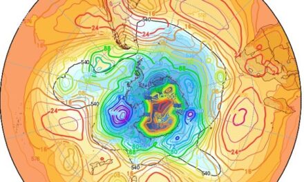
However, a feature that definitely can not be associated with winter, is the prominent vortex that developed south of Madagascar. This was indeed an early summer feature rather than a late winter one. What it did was to reduce the usual impact of the South Atlantic high as it crossed the sub-continent, but it also lead to strong zonal flows over Namibia in the upper air, i.e. above 25,000 feet.
The result is cold, dense air in the alto levels with very little moisture.
Meanwhile, the weather further north was basking in the sunlight, leading to very hot conditions over Owambo, Kavango and Zambezi. But moisture remained restricted and rain was nowhere to be found. A strong anti-cyclonic circulation developed in the upper level, beginning slowly on Tuesday but gaining prominence later in the week. The core lay over the Zambia Angola border and the clear skies that remained for most of the week indicated high pressure control in the upper air, very similar to the 2013 season.
What’s Coming?
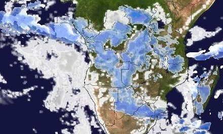
The effect of the passing high pressure cell remains over the weekend. This particular high is so prominent that at one point it stretched for over 10,000 kilometres from midway between South America and Africa to midway between Africa and Australia. Its presence is the major reason why local weather remains split along the southern half, northern half division. As the high progresses to the east, the very typical low pressure area lying across Angola, starts moving down the coastline from the Kunene mouth southwards across the Kaokoveld and Damaraland. By Sunday, it has developed sufficiently to the south to form a trough extending again from Angola to South Africa. Moisture remain restricted to levels between 20,000 and 25,000 feet, and it is possible that a so-called inversion layer may develop. This will bring the appearance of cloud along the trough line, but the high pressure control in the upper air remains, so precipitation will be very scanty, if any. Again it is the very typical Namibian situation of some moisture in the middle layers and the right mechanism to distribute it across the interior, but eventually disappearing in the dry air above. Another cold front passes the Cape on Tuesday leading again to the an intrusion of cold air from the south. Since a fairly hot low pressure area has by then developed over the inland plateau across northern Namibia, northern Botswana, western Zambia and southern Angola, a well-marked convergence line develops in its customary position from Ruacana to Mata Mata. Light rains east of this line is possible, starting as early as Sunday but probably continuing through Monday to Tuesday. West of the convergence line it will be windy, especially over the escarpment, but it will not rain.