


Weather overview and short-term outlook to Wednesday 27 May 2020
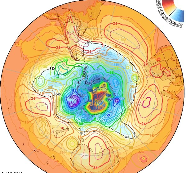
Visual: Sea level pressure for the austral hemisphere on Friday 22 May.
Source: Center for Ocean-Land-Atmosphere Studies at George Mason University, http://www.wxmaps.org/fcst.php
Recent Developments
Weatherwise we are in that phase on the calendar which John Olzsewski always described as the see-saw season. The reason why this is so can readily be seen in this week’s visual which shows the estimated positions of the chain of high pressure cells as they encircle the southern hemisphere more or less between 20°S and 40°S.
For the man on the ground it would be more apt to describe it as the season when nothing happens – the sun rises every morning about 22 seconds later and sets every evening about 12 seconds earlier, the skies are clear, wind is subdued, the mornings are fresh and the afternoons are warm. At the coast, Oosweer comes and goes with a four to five day regularity.
As can be seen in the visual, the high pressure cells are restricted to a well-demarcated zone that encircles the planet at the indicated latitudes. These cells are the main weather drivers in the so-called temperate zones, which includes Namibia. It is also important to note that the cell’s dominant feature, its core, is what determines weather further away at its rim, often around 1000 km or more away from the core. This is also the reason why meteorologists indicate the 1024 mB isobar in red. It marks that part of the cell that conforms to all the high pressure definitions.
The see-saw part comes in when the South Atlantic high approaches the continent. Since it revolves anti-cyclonically, its leading rim advects air from south to north. In mid-winter it is the herald of cold air from the antarctic but in the current phase, it has a lesser impact, usually restricted to the surface, and we experience it as a cool or cold wind from the south-west.
Once the South Atlantic high has passed Cape Agulhas, the leading rim tends to push cold air up the Mozambican channel, which then recurves over the continent, creating the intermediate ‘continental high’ before morphing into the southern Indian high pressure cell. This intermediate high, also rotating anti-clockwise, drives the air from the tropics into the southern African subcontinent, with Namibia on its western edge.
The resultant phenomenon is our see-saw weather. In the morning it is cold, the direct result of cold air flowing from the south-west into the Namibian interior but it is restricted to the surface level. As the day progresses, solar energy heats the land and it gets warmer. The incumbent air column then starts rising but only until about 14:00. As the sun’s angle decreases, the infused energy recedes and this whole column of air above Namibia then tends to sink albeit it ever so slowly. This leads to adiabatic compression which releases energy, and Namibians get to enjoy their warm afternoons.
This interplay between cold air from the south-west versus warmer sinking air from the tropics, is a daily occurrence until the overall weather stance has changed perceptibly into a definite winter pattern.
On the Radar
The lull in weather continues repeating the same pattern described above. The only feature of interest is how Oosweer develops at the coast and how far into the southern Namib it reaches.
For the duration of the weekend, warm weather at the coast continues, reaching deep into the southern Namib. This abates by Monday when the South Atlantic high makes landfall south of Port Nolloth. Monday night the southern Namib will be windy, cold, and possibly moist.
This intrusion shifts to the east and by Tuesday the Karas region turns quite cold with the wind coming from the south-east. By Wednesday the high’s core has shifted east and the colder weather will enter Namibia from the east. The colder nights can surprise as far north as Etosha and Grootfontein.


