25 July 2014
![]() What’s Happening?
What’s Happening?
The US government climate agency, known best by its acronym, NOAA, still indicates current conditions over the equatorial Pacific Ocean as neutral, but believes as we move closer to summer, around November and December, chances are 80% that we shall go into a full-blown El Nino. The most important question that now arises is how strong El Nino will it be. For practical purposes, the massive expanse of the Pacific Ocean is divided into two halves, east and west of the dateline (180 degrees longitude). In 2013, the half closer to Asia, was warmer than usual by some 1.5o C while that section closer to the Americas was cooler by as much as 2oC below average. This picture has now changed and the entire Pacific is between 0.5oC and 2oC warmer than usual. Given that the currents at the equator flow from the Americas towards Asia, it means west of the dateline will get warmer still as the season progresses. From a definitional point of view, conditions are still neutral but in actual fact, sea surface temperatures, for the past six months, have already indicated El Nino conditions, only these were rather weak, or at least not strong enough to merit the official El Nino label. Now it seems it is only a matter of weeks before the divergence from the mean becomes so elevated, that NOAA will officially declare an El Nino. Looking six months into the future, which is always a dangerous undertaking in meteorology, we are not facing a good rainfall season.
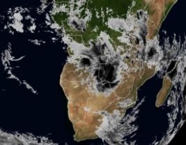
It must be stated, however, that these conditions can change, or remain anomalous for only a brief period, or return to normal on a trajectory not reflected by the prediction models. What is fairly certain is that the migration of warmer water from the Americas towards Asia, will eventually lead to enhanced El Nino conditions over that half of the Pacific. Exactly how it will impact us can only be determined closer to the actual event. The local weather was indeed very mild this week following a weekend of rather intense cold in the south. The unexpectedly warmer weather over the interior is as a result of low pressure control on the surface. The airflow is predominantly from the north, i.e. a warmer source, giving us our pleasant days. But the coast experienced cold, wet, foggy conditions as a result of the relative close proximity of the South Atlantic high pressure cell combined with the windflow from the west and north-west, and the lower pressure over the interior. All in all, a week where lower pressures over the sub-continent dominated the local scene.
What’s Coming?
The South Atlantic high pressure cell is not very strong, reading about 1032mB at its core but it is situated relatively far north meaning its impact on us is much bigger. Ahead of the high pressure cell, is driven a very strong cold front which makes landfall this Friday.
It bring us a mid-winter scenario with strong southerly and south-easterly winds, advecting the cold air as far north as Otjiwarongo. Friday night, and again Saturday night will be cold, but sub-zero is unlikely. By Sunday morning, even Rundu will feel a chill as its early morning temperature may go below 10oC. Yet, every day takes us a step closer to summer with a commensurate increase in the sunshine hours per day. This weekend, Namibia hits eleven hours of sunshine again, which has a major influence to neutralise the impact of the cold from the south. As a result, the high pressure cell collapses as it crosses the continent but it maintains its anti-clockwise rotation shifting the direction of the cold from south to east. However, this is of short duration and already Sunday afternoon should see a return to warmer day temperatures.
For most of next week the subdued high lingers over South Africa, meaning cold nights, but as the week progresses, a trough (low pressure) comes down the coastline from north to south. Tuesday and Wednesday look set to be very windy with strong Oosweer on Wednesday. As the pressure differential becomes less, the later part of next week should see warm temperatures over the interior and mild Oosweer conditions as far south as Sandwich Harbour.