


Overview for the week and 5-day outlook to Wednesday 14 February 2018
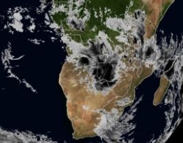
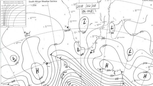
Visual: Satellite image of southern Africa at 06:00 on Wednesday 07 February and synoptic map of southern Africa on Thursday 08 February 2018.
Source: First image: Space Science & Engineering Center, RealEarth Imagery, University of Wisconsin – Madison http://realearth.ssec.wisc.edu/
Second image: South African Weather Service
What Happened
Two major shifts have occurred in the local weather scene, both present and visible for the duration of the week.
With a very active Inter-Tropical Convergence Zone situated almost on Namibia’s northern borders, conditions were just right for a tropical low pressure system to develop somewhere in the southern extremity of the ITCZ. This happened over Western Zambia and as confirmed by the satellite image, this was a very broad system, covering the better part of 2000 km on the surface.
The presence of this system relatively close to Namibian territory provided a consolidated source of moisture which needed only a little push to be advected into the Caprivi, across northern Botswana and into the Namibian interior. This happened from Wednesday onward readily assisted by a strong north-easterly windflow. It developed further during Thursday and Friday, eventually linking up with a prominent mid-level trough over central Namibia, producing widespread, but light, thunder showers from the north, through the central and eastern regions, into Hardap and even Karas.
The second event of note was the relative weakness and position of the South Atlantic high pressure cell. As is shown very clearly on Thursday’s synoptic map, this cell has weakened by about 8 mB and its core shifted south by more than 1000 km to the vicinity of the 40°S latitude. Meanwhile, the other major high pressure cell, the southern Indian, also weakened but less so, with its core some 2000 km south of Madagascar.
The area between these two highs opened up, driven in no small measure by the spill-over of the tropical low pressure system and assisted and amplified by the huge north to south conveyor mechanism of the mid-level trough. This created a five-day window for rainy conditions over Namibia which started on Thursday and will continue through the weekend to Monday night next week.
Another feature to note is the improvement in the so-called Indian Ocean Transport. Although not as strong as what Namibia needs, it has come back in strength over the past three weeks, mostly as a result of the consolidation of the atmosphere over eastern Africa. For the past four months, the eastern African atmosphere was highly fragmented with much high pressure control in the upper air, or so-called ridging. This always acts as an impediment to Indian Ocean moisture reaching central Africa.
In Namibia, moisture levels improved dramatically from a week ago. Now the daily average reading for the interior east of the escarpment exceeds 60% whereas until recently it hardly got above 30%.
What’s Coming
Both the tropical low pressure system over Western Zambia and the mid-level trough over Namibia are expected to remain strong and in place for at least another three days. There is some divergence in three leading outlooks regarding how far west the system will develop but there is general consensus that it will reach at least up to the escarpment.
The mid-level trough is powerful conveyor of moisture and when it interacts with a tropical low pressure system, copious amounts of moisture enter Namibian airspace. This same system also lowers the cloud base which always leads to improved chances for rain.
Although the tropical low pressure system is expected to wander somewhat to the east, it remains in close proximity to Namibia. While the rainfall prospects are diminished for next week Tuesday and Wednesday, the trough remains active albeit at a slightly higher elevation.
The rainfall outlook for the middle and latter part of next week is very similar to the outlook for the first half of this past week.
It is Namibia’s main rainfall period and only a small shift in conditions usually leads to a rather significant change in local results.


