Understanding weather – not predicting 18 October 2013
 What happened?
At this time of year there would tend to be a clash between departing winter-style patterns with an expected increase in summer-style patterns, i.e.a clash between colder and warmer airmasses. In our instance, we also have the increasing effect of climate change patterns to contend with.
So far, the wintry patterns have been generally restricted enabling the warmer influences to be more effective but even the warmth has limits.
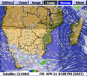
Translating this from words to charts, we see anticyclonic presence strongest along the 40oS range (so limiting colder penetration to all but the southwestern Cape) while its eastward pushing ridge ensures an inflow into (for present) the eastern sub-continent, very much in keeping with expectation, with an ability to feed some of its moisture toward the heat-inspired low pressure area present above us and much of neighbouring Botswana: again a situation to be expected on the daily weather charts at this time of year.
The potential of middle air advection has also been improved (with no cold front/troughs to deflect such inflow) so a persistent cloud band has appeared, somewhat narrowly, across our skies circulating around a shallow, but also persistent, middle air anticyclonic core above mid-continent.
This warmer influence is presently limited by dry air above it (the anticyclonic fringe) so the resultant Altocumulus cloud band is not so thick, yet still turbulent enough to assist occasional lower-based cumulus cloud in its convective thrust.
In this airmass, occasional thunderstorms and local showers occur.
Light, quite scattered, showers were recorded from Tuesday through Wednesday.
It is to the credit of the Australian Bureau of Meteorology that their daily synopses have, for some years now, featured a “trough line”, not a front, but a distinct angled separation of wind-flows. Such a trough line did much to accentuate the showery developments of the past couple of days.
What’s coming?
The continuing presence of the mid-Atlantic anticyclone, clearly marked from surface up to the 850hPa levels along the 40oS base, ensures similar ridge extensions so fostering a similar inland pattern until mid-week.
At 700hPa trough outlines shape close to our west coast, even more marked at the 500hPa level.
While there is little advection potential from tropical sources, this remains a positive reaction with the persistent convective, heat-inspired low pressure core anticipated, just about daily, at our surface level.
True to October: heat by day, some cloudy development in the northern parts: shower potential expected during the weekend, building (again) by mid-week.