


Weather 01 April 2016

What Happened
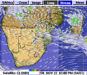
A succession of mild cold fronts passed the Cape during the course of the week. The first two followed one another in close succession, but other than the cooler nights, it was hardly noticed in Namibia. The third cold front, about two days after the first pair, lead to a marked decline in night temperatures across the southern half of Namibia, and some intermittent snow in the Eastern Cape.
However, none of the three cold fronts can be described as severe and the Eastern Cape snow had more to do with elevation than with polar air. Still, as is typical for Namibia, once the cold fronts were past Cape Agulhas, their northern push was deflected west by the lower pressure over the interior and the colder air came from the south-east and then almost due east. What kept the cold fronts from becoming really cold was the presence of two strong vortices, south-west and south-east of South Africa. These vortices usually develops in the col between two high pressure cells and their strong rotation and vertical velocity, tend to dissipate the impact of the high behind it. On the eastern side of the vortex, a strong north to south airflow develops, allowing barometric space for warmer air from the north to flow towards the south.
But the presence and influence of the high pressure cell behind the cold front can not be disregarded as was amply displayed during the week. The South Atlantic high pressure cell is an impressive weather event, and as it approaches the continent, it causes cold, windy conditions along the western South African coastline and the southern Namib coastline. As it pushes inland, and encounters the escarpment, it is forced aloft, leading to a cloud base of around 16,000 feet over the interior. To understand its effect, see it as a massive, flattened bubble that slowly encroaches Namibia, starting at Oranjemund and Lüderitz, and then, over the course of about two days, slowly spreads north and east. It is the outer rim of the high and typically measures about 1016 mB. As it moves over the interior, it displaces the warmer air from the north, leading to the mid and upper level troughs which are conveyors of moisture. However, this week’s high was so dominant, that whatever moisture entered Namibian airspace, was rapidly neutralised by the dry, cold air beneath the trough.
What’s Coming
Low pressure conditions continue over the southern African interior with a marked south to north airflow over South Africa, reciprocated by a north to south airflow over Namibia. On Saturday, the south Atlantic high pressure cell with a core reading of 1024 mB sits some 1500 km due west of Saldanha Bay, drifting slowly towards the continent.
The southern Indian high pressure cell, located south-east of Madagascar is somewhat weaker with a core reading of 1020 mB, expected to decline to 1018 mB as it moves east. Between the two highs a prominent vortex develops behind the last cold front which passed this week. This reduces the strength of the South Atlantic high and the core remains west of the continent until Monday when it gains mobility, pass Cape Agulhas and starts moving up the Mozambican Channel.
In the wake of this high, the signature trough develops from Angola into Namibia advecting some moisture into Namibia. By Tuesday the trough has split the country into a western half and an eastern half with the bias in the west.
This low pressure system moves south along the coastline, causing windy conditions on Tuesday and Wednesday along the coastal plain and up to the escarpment. As the trough migrates to the east, there is some chance of scattered, light showers over the north-eastern quadrant but spreading to the Kalahari by the second half of next week.


