Understanding Weather – Not Predicting -16 December 2011
What happened?
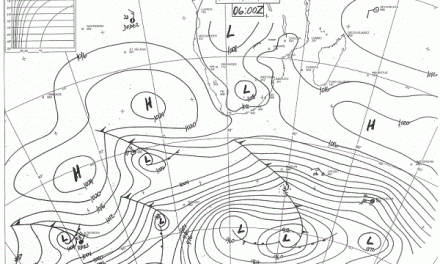
The key pattern is an equatorial low pressure core over Angola and a well-developed trough-line extending across western Botswana with the ability to bring thunder storms to the Kavango and Caprivi regions.
The frequency of cloud development above the Kavango valley and adjacent areas was there to be seen. It showed that the feeding anticyclonic core lay above the Mozambique Channel and the convergence area would match the band from Angola south-eastwards.
The Atlantic pressure pattern gave a differing response. While the core remained strong in mid-ocean, its southward push did nothing to drive the whole complex pattern eastward into the Indian Ocean area. So cold front activity prevailed along the south coast and the coastal low, running ahead, prevented any real moist air activity any deeper inland than the coastal belt on the east African coast.
While this is disappointing for rainfall prospects, we should also remember that this is December, still one month early on the “average” rainfall calendar. The main rainy season only starts in January.
The synoptic charts showed by Thursday, a ridge thrusting across the Cape and building an anticyclonic core off the continental east coast: just where it should be in fact.
While this pattern has a wintry stance, it also reflects the hemisphere-wide synoptics. Across the hemisphere, anticyclonic cores readily cling to their 40 to 45oS tracks taking themselves south of the continents and feeding in, an undercutting flow of colder air creating active weather around the hemisphere. This is all part of the persisting La Nina control of the hemispheric pattern. That there is a delay in our part of the world can be ascribed to the undercutting which is creating vortex circulation close to Madagascar. For some days, this situation absorbed much of the airflow potential which would otherwise have thrust into southern Africa so pushing the trough that much further west. As such this is a likely variable to the weather pattern.
What’s coming?
As the new week unfolds so the ridge develops its own anticyclonic core and, according to the forecasts, strengthens this core to being the highest pressure (1033hPa) for these few days across both the South Atlantic and Indian Oceans. Although the wind models are not too enthusiastic about developments, other models give a deepening area of lower pressure forming above mid-continent and, as one would expect from the strengthening core, is pushed more into Namibian skies. The rainfall outlooks offer more across the northeastern, eastern and into central Namibia with a developing extension into the southeast. This curving airflow does fit in with the pressure pattern. Not much rainfall prospect though for the western parts, but being December the current outlook is still positive overall.