


The Week’s Weather up to Friday 01 December. Five-day outlook to Wednesday 06 December 2017
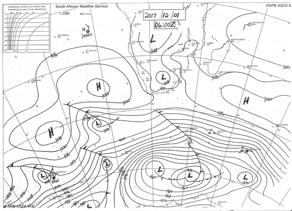
Synoptic Map: Early Friday morning, 01 December, as published by the South African Weather Service. Source: www.1stweather.com/maps_fx.php
A comparison of the synoptic map earlier in the week with Friday morning’s map shows a weakening of the cores of both the South Atlantic and the southern Indian high pressure cells. At the same time, it is very obvious that the highs are fairly static and that over the course of a week, only minor movement has taken place. By the end of this week, the cores of the two highs were, give or take a hundred or so kilometres, still in the same positions where they were at the beginning of the week.
This observation offers two important considerations to interpret current weather conditions, and to form a picture of what to expect between now and the solstice on 22 December.
It is a typical Namibian occurrence that the main rain season only starts after the solstice. This holds true for the whole country although as a general rule of thumb, the further south, the later the arrival of significant rains.
When so little has changed in the course of a week, it becomes a valid question how much will change over the next three weeks. The synoptic comparison may provide some clues.
At the beginning of the week, the southern Indian high’s core sat due south of Madagascar with a fairly normal barometric reading of 1024 mB and a strong influence over eastern South Africa. By Friday, the pressure has reduced to 1020 mB, the core has become elongated, and shifted east by about 600 km.
The South Atlantic high which measured a fairly strong 1028 mB also lost 4 millibars, reading 1024 mB on Friday but the core has contracted considerably. However, its position is unchanged with the core about 1000 km due west of Saldanha Bay.
Over most of the interior, low pressure conditions reigned, except for a small remnant of the southern Indian high over southern Mozambique. The southern African central plateau measured 1012 mB up to about Windhoek and 1008 mB further north. The biggest low pressure impact was over the western half of the sub-continent, which is also the underlying reason for the continuing very hot conditions. By Friday, the low pressure control was universal and a visible low pressure system has developed over South Africa, with a marked cyclonic circulation on the surface, also at 1008 mB.
The pressure differentials can be ascribed to warmer sea surface temperatures in the Indian Ocean and colder water in the South Atlantic. Furthermore, the South Atlantic high tends to be quiet at its core while its southern Indian counterpart has a noticeable rotation albeit it still very slow. The action with both only happens on the outer rim at around 1016 mB, usually observed as sunny clear skies but accompanied by mild to fresh winds.
All these elements were at play for the duration of the week. The result was visible cloudiness in Namibia’s skies but with precipitation only east of the convergence zone which ran from southern Angola through the Kavango into central Botswana and into central South Africa east of the Karoo.
Current conditions indicate a lower expectation for significant rainfall in Namibia except for perhaps Kavango East, Bwabwata and Zambezi. At the same time, these areas will remain unusually hot while the rest of Namibia will only be slightly cooler depending on cloud cover.
What’s Coming
Both oceanic highs are stuck. Very little movement is indicated or expected. Low pressure conditions between 1012 mB and 1008 mB continue over the interior. This continues throughout the weekend.
Due to the continental low pressure and anti-cyclonic air circulation, hot to very hot conditions continue. A weak mid-level trough forms somewhat further east, skimming through Onhangwena, both Kavangos and Otjozondjupa along the Botswana border. Isolated showers may occur in the convergence zone but actual precipitation will be small.
It is only by Monday that conditions change slightly. The South Atlantic high budges from its three-week locality, moving around Cape Agulhas to the southern end of the Mozambican channel. Low pressure conditions over the interior intensify with the highest concentration over Namibia. While this spells very hot conditions, it also implies a north to south airflow which should bring in substantial moisture.
The moving South Atlantic high creates space for the convergence zone to develop to the west.
For Tuesday and Wednesday there is a reasonable expectation for rain over about one third of Namibia. This is the area east of the convergence line which then runs in its customary summer position from Ruacana through the interior to about Mata Mata.


