


Overview for the week and 5-day outlook to Wednesday 02 May 2018
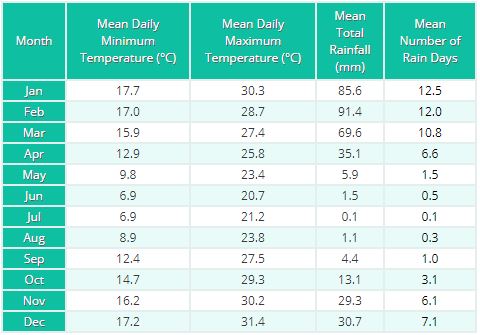
Visual: Monthly mean temperatures, rainfall and rainy days for Windhoek based on 30-year data
Source: World Weather Information Service published by the World Meteorological Organization, a United Nations agency. http://worldweather.wmo.int/en/city.html?cityId=1830
What Happened
Local weather is unmistakeably in that in-between phase that marks the transition from late summer to early winter. It is characterised by high pressure control on the surface, manifesting in cooler nights, but dispelled by fairly warm to hot late afternoons. The most obvious feature is the almost complete lack of cloud.
This type of see-saw weather may continue deep into May. However, as witnessed by events in the Western Cape on Tuesday, Wednesday and Thursday, the onset of severe winter weather started early this year. Usually when this happens, the southern African interior, is subject to pervasive high pressure control and only the Namibian coastal plain and the winter rainfall zone are prone to low pressure intrusions.
The two systems do not originate from the same source. Lower pressure on Namibia’s northern border comes from southern Angola. During summer, it will follow the regular trough that develops at the middle levels between 15,000 and 25,000 feet. During winter, or at the onset of winter, as higher pressures over Botswana and most of South Africa become the norm, there is a strong anti-cyclonic circulation more or less at the 850 mB level. This is close to the surface so it has a direct impact on the intrusion of air from the north.
The north-western rim of this large anti-cyclonic wheel turning over southern Africa, tends to act like a massive impeller, bringing the low pressure system from south-western Angola into Namibia’s Kunene Region, and from there pushing it south along the coastal plain. How far south this system develops depends on how long the rest of the sub-continent remains subject to high pressure conditions.
Winter rain, on the other hand, is the result of the severe low pressure systems following in the wake of cold fronts. These areas are usually strongest at the front’s southern extremity as seen this week when the Cape Town flooding was accompanied by strong winds and storm activity. The process is further amplified by the Western Cape’s topography. Both the frontal system and its accompanying vortex, are driven by the South Atlantic high pressure cell. Since this cell grows stronger in winter, and since it is so massive, it drives the front across the Cape Peninsula and up the mountains. This leads to strong updrafts, convection, and consequently precipitation but only in the lower levels. In the upper levels, the entire system is driven by the jetstream at the 200 mB level. This time of the year, that jetstream is zonal from west to east, and very strong. It is the reason why these systems move so rapidly as opposed to tropical systems which tend to stay longer, or travel much slower.
The system that brings winter rain is separated from the northerly tropical system by about one thousand kilometres but since both systems are continuously in flux, it sometimes happens that the two link up. There is such an opportunity which may happen around Monday or Tuesday next week.
When this happens, the low pressure over the northern Namibian coastal plain has the potential to form a belated mid-level trough, linking up with the frontal system over the Western Cape. These occurrences are what typically brings Namibia its last bout of late summer rain, and possibly the first winter rain to the Sperrgebiet and the areas along the Orange River Valley.
What’s Coming
Over the weekend, the see-saw weather dominates the entire Namibia above the escarpment. Nights in the south will be cold, and cool from Otjiwarongo further north. But the afternoons will be warm and the airflow will be from the north-east with clear skies.
The low pressure system over the coastal plain growths in strength leading to a noticeable pressure differential between the interior and the low lying areas below the escarpment. This will lead to mild Oosweer over the central Namib, getting stronger further north.
From Monday to Wednesday, Namibia is split into a western and an eastern half with high pressure control in the east, and low pressure in the west. This means cold nights and warm afternoons for the east, and windy conditions on the coastal plain.
By Tuesday it is possible that the Namibian low pressure area may link up with the much stronger Western Cape low pressure system. If a proper trough forms, then it is quite possible that the Namibian interior may see some light rain with the bias in the south.
The intention is not to create false hope. The table at the top shows that Windhoek’s mean May rainfall over 30 years did not exceed 6 mm, so history speaks against the likelihood of any good thunderstorms during May.


