Understanding Weather – not predicting – 04 April 2013
What happened?
While the southern hemisphere has experienced astonishing downpours, in Namibia we had good reason to query our prospects.
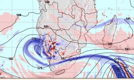
The desirable weather patterns were on the way though. A sharp cold front extending northward from an intense vortex close the Antarctic shore was advancing east toward the Cape. The upper air trough was just as significant. The significance lay in an obvious clearance of the already weakening middle level anticyclonic core which had taken root across the South-Atlantic for the past dozen or so weeks. Within a couple of days, the southerly airflow was replaced by a developing flow from the northwest bringing with it some moist air throughout its deepening stream of air. Initially, the air-stream was both narrow and limited in its depth. However, the increasing impetus of the circulation provoked by the advancing cold front trough and the tightening isobars proved itself. Within 12 hours the positive development of both convective cumulus cloud and the increasing middle level clouds showing turbulence were visible and active. Shower activity appeared more widespread.
The vortex core was also active. Responding to the thrust of the mobile anticyclone advancing along the 40S range, the frontal push sagged along its northern reach and developed its own closed core vortex: a cut-off low was forming. This development enriched the northwesterly flow now from surface to some 12 000 feet while providing further stimulation to the deepening upper air flow so much so that by Thursday evening a moistening airflow extended to the 40 000 foot level, 200hPa in another description
As these synoptics got to work, the advection also attracted Congo Air by the Friday afternoon.
For the next 48 hours, Namibia was engulfed in broad, deep moist air layer with active clouds introducing their calling card: rain!
Very few places will have received no rain; convergent ability within such a favourable airmass enabled falls of 10mm or more to fall and/or recur; much heavier falls, to the 70mm range have also been reported. Only the Okavango valley and Caprivi lay beyond this moist swath.
Was this rainy event just a local performance, or was it in cohesion with a much broader synopsis? Pacific Ocean neutrality seems benign, while anomalous events recur in both Indian and SW Atlantic weather arenas. This past event had some roots in the more southerly Atlantic synopses, our weather eyes need keep watch to our distant west.
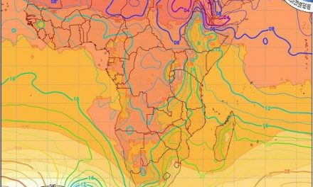
What’s coming?
While this weekend keeps the cooler, drier air flow associated with anticyclone rounding the Cape, with its upper air extension holding sway over the southern sub-continent, moist air persists across the northern sub-continent with some prospect of showers for the now-remarkably dry Okavango valley and the neighbouring Caprivi.
An immediate return is doubtful this week, but with anticyclonic cores active so far south, favourable synopses cannot be ruled out.