


The Week’s Weather up to Friday 08 September. Five-day outlook to Wednesday 13 September 2017
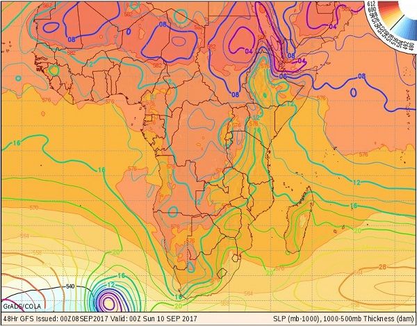
Map: Sea Level Pressure on Saturday 09 September and the height of the 500 mB surface indicated by the coloured areas. The forecast map is relevant to the 12-hour period preceding the date at the bottom. Source: GrADS/COLA.
The surface pressure map, although based on data collected 48 hours ealier and relevant only to Saturday, offers a good interpretational framework to understand what transpired during the week.
The week started with a typical late winter stance. The South Atlantic high pressure cell lay some distance offshore the west coast while the southern Indian high sat just south-east of Madagascar. A remnant of the continental high was present over the highlands of South African and Zimbabwe. Airflow over most of the sub-continent was anti-cylconic on the surface and zonal in the middle levels. The South Atlantic jet stream at 45,000 feet was normal. The only anomaly was found in the alto levels, i.e. 45,000 to 56,000 feet where a stong zonal flow from the Indian Ocean ran across central Africa from east to west, then recurved southward over the Atlantic Ocean close to West Africa and re-entered the continental space along the Angolan and northern Namibian coastline.
As the week progressed the surface impact of the continental high gradually reduced, the core of the anti-cyclonic circulatioin moved to a spot roughly over the tip of the Caprivi at Mpalila Island and an area of lower pressure straddled the Namibia Angola border extending eastward across Babwatwa. Windflow over Namibia turned from east to north-east to north-west.
The result was somewhat windy conditions, generally lower pressures not exceeding 1016mB and a dominant airflow from north to south. A low pressure system did not develop over the coastal plain so most of the Namib was fairly quiet.
The predominantly northerly airflow advected enough moisture from Angola to show up as scattered cloud running from north-west to south-east in the mid-levels. This band of cloud followed a clearly demarcated convergence zone also running from Angola to the Kalahari. The surprisingly dense cloud formation in some areas over the central high ground even produced a few drops of rain in various localities scattered widely across the country.
By Friday, the southern Indian high was of moderate strength with the South Atlantic high slightly weaker and far offshore, more than 2000km away. Ahead of the South Atlantic high a low pressure area formed with a weak clyclonic circulation. Immediately following this low pressure area is a frontal system which can be seen on the map where the 540 dam line runs. This is the black line where the 500mB surface is relatively low (5400 metres ASL) and where the surface temperature is 0°C.
The week came to a close with hazy, cloudy conditions in a wide swath across the Namibian interior from Angola to the Kalahari with humidity levels just touching 30%.
What’s Coming
The surface pressure map shows four distinct elements: in the bottom right hand, the southern Indian high is still south-east of Madagascar with a core reading of 1028mB; the next approacing South Atlantic high is in the bottom left corner with the frontal system and the weak depression just ahead of it; the barometric pressure over the entire Namibia is on the low side; and the atmosphere over East Africa is fragmented.
From the positioning of these four elements one can infer that the southern Indian high will have limited impact on the continent. The South Atlantic high, due to make landfall around Tuesday next week is unseasonally strong at around 1032mB and the frontal system is well developed. But the depression ahead of it will dissipate much of the high’s strength and it will slip around the continent at Cape Agulhas with the depression turning into a Southern Ocean trough that will enhance the north to south airflow over the western half of the sub-continent, meaning that over Namibia moisture will continue to be brought in from Angola.
However, the South Atlantic high, as always, is a mighty animal and not easily slain and by Wednesday next week it will spread across most of southern Africa south of the Orange River valley.
From the north warm, moist air will continue to penetrate the Namibian interior resulting in a typical early-summer pattern of cooler air flowing back from the high across the Kalahari and into Namibia from the east, while warmer, cloudy conditions move in from the north.


