


Overview for the week and 5-day outlook to Wednesday 07 November 2018

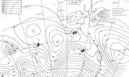
Visual: Surface synoptic map of southern Africa on Thursday 01 November.
Source: South African Weather Service, www.weathersa.co.za//media/data/observation/synoptic/ma_sy.gif
What Happened
Thursday’s midday synoptic map provides a good snapshot of this week’s weather development. The map shows elements of both winter and summer patterns although the overall stance leans more to a winter pattern with the obvious exception Namibia’s north-eastern corner.
Generally a cooler week for the interior south of Etosha which resulted from the South Atlantic high pressure cell’s impact over the south-western two-thirds of Namibia. This produced some surprisingly cool nights across the southern half with the minima going as low as 10°C in the higher areas of the interior.
A high pressure cell by definition constitutes a sinking air mass but it can have a local effect in two opposing ways. The first is when there is high pressure control on the surface, (the direct result of the proximity of the South Atlantic high) while the second happens when there is high pressure control in the upper air, or so-called ridging. This is what we had two weeks ago with the sweltering late afternoons.
This week’s high pressure control was surface bound and it was driven by the South Atlantic high migrating around Cape Agulhas but with its effect extending well into South African, Namibian and Botswana territory. This lead to the cool nights. It is essentially still a remnant of the winter pattern when the location of the 1024 mB isobar generally indicates the high’s core. As can be seen from the map, it still straddles the parallel that runs through Saldanha Bay from which it can be deduced that out to sea, winter conditions are still in control.
Opposing this impact from the south-west, is the so-called anti-cyclonic circulation which is a standard summer feature of southern Africa. With daylight reaching 13 hours this week, the amount of energy received during daytime is approximately 16% more than the energy lost during the night. Consequently, central and southern Africa is heating up fast as it moves deeper into the summer season with a commensurate effect on overall temperatures in general and daytime temperatures in particular.
This airflow from the north-east advects warmer, moister tropical air from Angola and Zambia into Namibian airspace where at some point, it encounters the cold, dense air from the south-west. Depending on the relative strength of the two systems, it can lead to cloudiness which typically occurs east of the convergence line. This did not happen this week for a third reason, i.e. the strength and direction of the jet stream in the stratosphere
This week, the South Atlantic jet stream was particularly strong and active, also blowing from a south-westerly direction like the high on the ground, but clearing the upper air of moisture as it pushes the convergence line to the east. Blowing strongest between 35,000 and 45,000 feet, the jet stream is most powerful at the height where cumilo-nimbus cloud formation usually takes place. The jet stream can be seen as a huge blower that simply clears the upper air of everything it meets in its path.
Thus the clear skies were in part due to the activity of the jet stream.
What’s Coming
In the wake of the departing high, a fairly intense low pressure system develops over the ocean south of the southern Cape. Lower pressures are present over Namibia forming the signature mid-level trough reaching all the way from Angola, across the eastern half of Namibia, through Botswana and into South Africa, linking up with the low pressure system in the south.
This will bring a broad band of cloud into Namibian airspace east of a line running more or less from Ruacana through the interior to Mata Mata. The outlook expects widespread light rain across Ohangwena, Kavango West, Kavango East, eastern Otjozondjupa and Omaheke along the Botswana border, but only on Saturday and Sunday.
This system intensifies on Sunday and may lead to isolated but strong downpours in some areas. The geographic distribution remains more or less the same as on Saturday but there is an outside chance that the system may actually develop a few hundred kilometres further to the west due to the absence of a high pressure cell.
The jet stream remains very active meaning that by Monday the trough has shifted north-eastward with only a slight chance for rain over Kavango East, Bwabwata and the Caprivi on Monday and Tuesday. By Wednesday the system has moved away from Namibia to Zimbabwe and eastern Botswana.
No rain is indicated for the interior.
The next approaching high makes landfall by Monday afternoon bringing very windy conditions to the southern Namib on Tuesday. Because of the high’s rapid shift from west to east, Tuesday morning will again see cooler temperatures in the south-western quadrant.
Overall, Monday, Tuesday and Wednesday should be clear with very limited cloud formation and zero expectation for rain expect for the northern-most part of Kavango West along the Angolan border.


