Understanding Weather – not predicting – 19 July 2012
What happened?
Yet again the previous weekend brought an active vortex pattern with a marked northerly extension. A low pressure trough with a cold front as its core, marked a complete reversal of wind flow (NW to SE) as it extended deep into Namibia.
While experiencing at first hand a blistering example of the wind-chill factor, somebody enduring the same experience commented that if this is global warming at work, what more is there to endure?
Like many scenarios, the greater the distance, the clearer the picture.
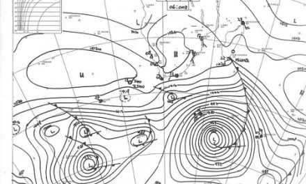
As we have seen, not only across Namibia but, in fact, at least hemisphere-wide, the whole climate pattern has shifted its geographical range from the usual pattern. The high pressure belt has moved at least 10 degrees further south.
This shows anticyclonic cores riding with consistent equanimity along the 40oS latitude. Consequently the wind patterns created by these high pressure areas draw in air from more southerly, colder, latitudes.
Advect this polar air further north and the result is the cold blast we experienced. Increased wind strength is shown by the tight isobaric patterns identifying the cores of high and low pressure centres remarkably close to each other. Cold temperatures become significantly more potent when they occur accompanied by increased wind speeds, not perhaps much on a speed scale but emphatic enough to create temperatures which feel that much colder to the warm-blooded. The wind-chill factor is potent and in our environment often leads to small stock mortalities.
So where does global warming come in? While the more poleward positioning of the high pressure cores does bring colder air northwards, it also pushes significantly warmer air deep into the temperate climate zone, even to the edges of the polar, frigid, airmass. Temperatures well above the usual are frequently recorded as well as their effects. Melting ice is one of them. Such warm intrusions excite vortex activity, creating exceptionally low pressures, even below 940hPa, at their cores. Wind speeds become equally exaggerated above the usual scale. While the northward flow, the Trade Winds (so named because of their reliability for both their strength and direction for the sailing navigator) remain equally consistent.
Again, by mid week significant warming gave an appreciated return to normal temperatures.
What’s coming?
A trilogy of cold fronts are to pass south of Namibia during the Friday to Monday period. The northern stretch is limited to our south, from somewhere between Mariental and Keetmanshoop. Some rain is possible across the extreme south. The cold air penetration is limited by the rapid succession of these fronts and their vortex cores away to the south. The very cold air to the west of the cores is turbulent enough to allow secondary cores to develop within this flow so restricting any major surge of this cold air further to the north.
A not very well identified, but still persistent, anticyclonic core remains above the mid-continent with little deviation from the mild to warm daytime conditions prevailing across northern and central Namibia.
Coastal easterlies appear limited for the time being as a northerly drift dominates.