Understanding Weather – not predicting – 14 December 2012
What happened?
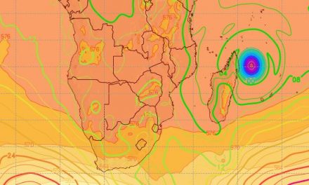
”Weather” this week caught the early bus to arrive one day early. While quite active weather persisted across the northern regions, the promise of a midweek return was accelerated by the development of a cut-off upper air vortex off-shore the Orange estuary. Extending throughout the troposphere, its ability to activate a deep moisture inflow brought an active air-stream into the central and southern skies. A requisite inflow of surface moisture arrived by Wednesday morning.
More than once we have noted a level of disarray when piecing together the various synoptic patterns and their associated air-masses. What may be called a conflict of interests has arisen and resultant weather systems do not necessarily evolve to their expected fruition.
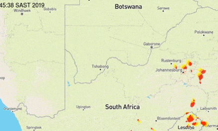
Locally, the expected thundery weather developed quickly above central and southeastern Namibia. The northern activity persisted but the potential of a link between the two was thwarted by an inflow from the west, around the northern side of the vortex. The prospect of a link would emanate from a more dominant circulation round the periphery of the anticyclonic core to the east.
While the northern pattern had marked equatorial links, the southern pattern was diverse.
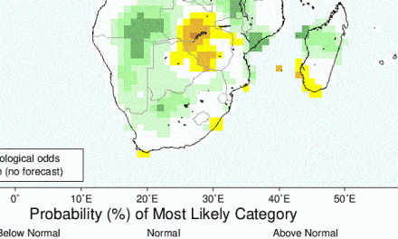
Causes for the incompatibility could be attached to the wobbly equatorial Pacific pattern. The mid-year ENSO potential failed, but its brief outline may have sent a ripple of disturbance through the airwaves of the hemisphere. An ENSO influence could explain the vaguely persistent dry air belt aloft, while the opposite sees regular moist inflow to the eastern sub-continent and upper advection across mid continent, all supported by anticyclonic movement around the continent.
As the week closed, upper air activity saw the development of an upper vortex core above central and southern Angola, drawing in a deep flow from the central equatorial region. This equatorial low has an ITCZ footprint with this cross-continental inflow. It also provides a reservoir of moist air from which adjacent advecting airflows can tap and bring such moisture further south.
* ENSO – El Nino Southern Oscillation
* ITCZ – Inter-tropical Convergence Zone
What’s coming?
Being immediately adjacent to this spread of moist air, thundery prospects continue for both the north and northeast throughout.
The upper cut-off vortex departs by Friday, the west-wind influence weakens, exposure to favourable lower level flows returns by weekend, but westward penetration is limited at first.
Tuesday to Wednesday offer a rainy outlook for much of the central interior. Daytime heat generated over the interior creates an a low pressure area over Namibia, Botswana, southern Angola and western Zambia. This drives the southward circulation of moisture. Conditions remain favourable throughout next week for this airflow to penetrate far south and west. Unbroken airflows from the east supplement this prospect.
For December, this keeps a positive stance: a wet northeast with an adjacent moist presence