


Overview for the week and 5-day outlook to Wednesday 14 March 2018

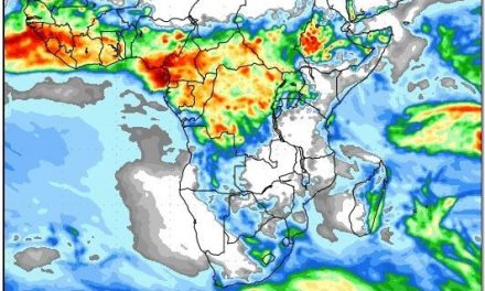
Visual: Outlook for Wednesday 14 March for surface pressure and the vertical depth of the atmosphere from sea level to 500 mB. Source: GrAds/Cola – George Mason University, http://www.wxmaps.org/fcst.php
What Happened
A strong zonal airflow from the east encountered the outer rim of the South Atlantic high pressure cell more or less over the Namibian escarpment. Where the warmer system from the north ran over the higher pressure on the surface, a broad convergence zone was the result.
The convergence zone reached from southern Angola into the Namibian interior. On its western flank it covered the northern Namib and the Kunene region. To the south, it followed the escarpment southwards to around Maltahoehe. From there it cut inland across the Swartrand to Keetmanshoop and beyond to the South African border. To the east it covered two thirds of Namibia bringing widespread rains starting on Monday, climaxing on Tuesday with a little rainy tail that lasted into Wednesday night.
Most confirmed rainfall measurements were in the 25 mm order with a few isolated showers that produced between 45 and 55 mm. The highest confirmed rainfall of 65mm was at Ruacana indicating the westward expansion of the convergence zone, and the enhanced convection over southern Angola, the Kunene Region, Owamboland, the interior of Erongo and the Khomas Hochland.
The rainy spell was the result of the stance and positioning of the two major high pressure cells, and the north to south movement of tropical storm Dumazile which grazed the east coast of Madagascar.
When a cyclone moves down the east coast of Africa, its clockwise rotation draws air away from central Africa creating a zone of higher precipitation on its northern rim but out to sea. Its southern rim, although not devoid of moisture, carries considerably less water. But here, the direction of airflow is reversed, bringing air from the Indian Ocean into southern Africa. (See last week’s discussion)
If the cyclone follows a track east of Madagascar, the impact on the continent is lessened by a combination of distance and the topography of the island. It is only when the cyclone’s core reaches the southern tip of Madagascar, that its full power manages to cross the island, traverse the Mozambican Channel and enters southern Africa through Mozambique. This all started happening during Sunday and by Monday the local effect became visible but it needed another day of travelling time before its full impact reached Namibia. It was this push from the southern half of the cyclone that caused the strong zonal flow from east to west which brought elevated moisture levels into the Namibian atmosphere.
By Thursday morning the South Atlantic high, although not very strong, has moved closer to the continent and it shoved the convergence zone to the east. By Friday it was still visible on satellite images but its location now ran from south-eastern Angola through Botswana into the South African interior.
What’s Coming
Over the weekend light precipitation is still possible for Kavango East, Bwabwata and the Caprivi but falls will typically be less than 20 mm. There is also an outside chance of rain in Bushmanland and the Otjozondjupa Region along the Botswana border but here falls are unlikely to exceed 5 mm.
It will also be very windy over the southern Namib and there may be some low-level cloud present in the Sperrgebiet and along the Orange River Valley as far inland as Nooroewer. The chances for rain in the south is however almost zero.
A second round of zonal flow from the east starts during Monday bringing some cloudiness to the Namibian interior on Monday and Tuesday. At the same time, a weak mid-level trough follows its regular path from south-eastern Angola through the Namibian interior up to the Orange River and beyond. This may produce some very isolated showers but the chances are very low.
Overall, the rainfall outlook for the next five days is bleak.
The interesting feature to watch is another tropical cyclone that is expected to become visible by Monday a few hundred kilometres north-east of Madagascar. At this point the jury is still out whether it will track east or west of Madagascar.
If it tracks east, we will have a repeat of this week’s weather in about 7 or 8 days. If it tracks west into the Mozambican channel, we can expect some dramatic rain developments over most of southern Africa.
The map shows the cyclone’s most probable position next week Wednesday.


