06 June 2014
![]() What happened?
What happened?
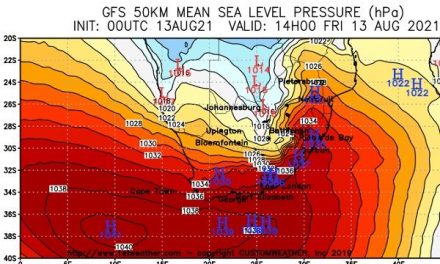
This winter’s first major South Atlantic high pressure cell with a core reading of 1028mB became visible on our radar by Tuesday. At that early-week point, the core was relatively far south, at around 40 degrees latitude but it gradually moved slightly north during Wednesday as it approached the continent. By Wednesday evening the outer rim of the cell made landfall and at the interior surface elevation of about 1400 metres asl, it brought temperatures down sharply to between 5 and 6o Celsius over the southern half, and around 7o Celsius over the northern half. This high pressure cell carried the hallmarks of a typical winter pattern with a strong core, relatively slow eastward shift, and a major impact starting in the south west then backing around to south east and eventually east, as the core slipped over the sub-continent. Yet, despite the presence and activity of this strong cell, the weather for the first half of the week was all low pressure induced. As noted last week, a complex succession of low pressure cells galloped from east to west around Agulhas, each carrying with it a cold front. Ahead of the cold front, airflow was mostly from the north, leading to warmer conditions during the day, and cooler, but not yet really cold, overnight conditions. Again, as is usual, the further north one went, the higher the day temperatures, even as high as 29o C in Owambo, Kavango and Caprivi. Obviously, the reverse is true for the south. In the south, the northern rim of this cold pressure cell lead to windy and wet conditions. However, during Wednesday night, conditions changed rather dramatically.
On the outer (leading) rim of the high pressure cell, where it meets and interacts with the very extensive area of low pressure ahead of it, it created a windy strip which acts like a large blower moving cold air from far south. In covering most of southern Africa, it also blows across Namibia, beginning at Oranjemund, thereafter systematically shifting its impact north-east until eventually, about two days later, the cold air has covered the whole country. As the cold air moves north, it is warmed by daytime solar energy, thus the frigid effect is incrementally limited, but the day temperatures are still markedly lower than the norm for the northern regions.
By Thursday, this high pressure cell has moved across the entire southern Africa lingering with its core over the North West Province in South Africa, but influencing local weather as far east as Mozambique and as far north as Zambia.\ Interesting for us, once the high pressure core lies over South Africa, the cold no longer comes from the south or south west, but from the east. This is due to the anti-cyclonic circulation of the whole system. In other words, the origin of the cold air is still the outer reaches of the Antarctic circle, but the local driver now feeds it from the east creating those typical frosty mornings in Omaheke with cold flowing in from Botswana.
What’s Coming?
This week’s major high pressure cell is briefly interrupted by a weak low pressure area, but lying further south. This temporarily relieves temperatures over the weekend, compared to Thursday and Friday, but the next even more intense South Atlantic high pressure cell is already only some 2000 km off the African west coast. With a core reading of 1032mB (at this stage) it will be even colder and more intense as it approaches the continent, displaces the last vestiges of the weak low pressure area and grips the entire sub-continent from Monday night onwards. Next week is bound to be a cold week, although around the middle of the week, there is the possibility of a weak trough (low pressure area) developing over the coastline north of Swakopmund. This may lead to subdued Oosweer conditions but only from Hentiesbaai further north. This is however opposed by the next approaching high pressure cell (the third in just over a week), and by the end of next week, windy and cold, even very cold, conditions will prevail.