


Weather 05 February 2016

What Happened
A fairly hot week to start with, then moderating into more bearable temperatures as the encroaching South Atlantic high pressure cell gradually started influencing surface conditions.
The high pressure intrusion from the south was marked by a pronounced south to north airflow, which grew stronger as the week progressed, leading to lower nighttime temperatures from Wednesday onwards. This effect reached north to about Otjiwarongo but was offset during the days, especially south of Rehoboth and along the Botswana border where lower pressures lingered up to Friday.
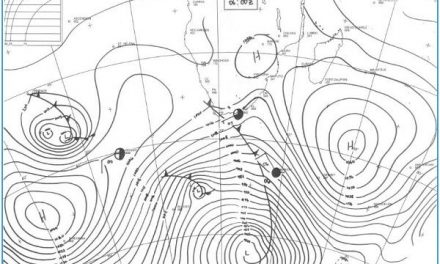
The week started with a conventional synoptic pattern. Both high pressure cells, Atlantic and Indian, were situated on either side of the continent, more or less on their expected trajectories. This created a typical “balanced” weather pattern manifesting over Namibia as higher pressures in the south and lower pressures in the north.
The inter-tropical convergence zone (ITCZ) is still present on the Angola Namibia border, slightly reduced in intensity from a week ago, but still well-demarcated. The low pressure conditions over the Kunene enabled the ITCZ to shift towards the west, eventually moving over the ocean near the Kunene mouth. This created a core of vertical activity covering some 500 km from the coastline to Ohangwena. The result was widespread rains over this area with surprisingly good intensity.
From this low pressure core, a weak mid-level trough lay over a broad swath from north to south bringing some cloudiness to the inland plateau but with very little precipitation. The exception was the south where isolated light showers were recorded from the Karas region.
By Friday, the migrating South Atlantic high has covered most of Namibia, mopping up all remaining moisture up to the southern boundary of Etosha.
A development that merits close observation is the gradual intensifying of a strong vortex just offshore west of Madagascar. This week its impact was minimal, but it is expected to become stronger over the next week.
What’s Coming
The weekend starts with the remnant of the former South Atlantic high now situated directly south of the Mozambican Channel. This departing high quickly morphs into the southern Indian high with considerable strength, its core some distance south-east of Madagascar. On the high’s northern rim, a large area of lower pressure becomes more intense, developing into a proper tropical depression. This is the first this summer so close to the continent. The depression may develop into a real cyclone but that we shall only know by the middle of next week.
Meanwhile, west of the continent, the next approaching South Atlantic high is far off and weak, again creating room for the ITCZ to follow the trough that develops from south-west Angola into Kunene and from there moving towards the south-east until it reaches the Kalahari along the Botswana border.
Monday, Tuesday and Wednesday next week is marked by high pressure control over south-eastern Africa, and low pressure conditions over the west, which includes Namibia. The mid-level trough will again advect considerable cloudiness, first over Kunene and then spreading south to cover the inland plateau.
However, conditions are not ideal for precipitation, at least not until the tropical depression west of Madagascar has come into full bloom.
The dynamic interplay between this vortex and the southern Indian ocean high pressure cell immediately south of it, has the potential to dramatically change the weather outlook from around 12 February onwards (one week from now).


