Understanding Weather – not predicting – 19 October 2012
What happened?
For some months Namibia has been on the borders of or alongside a wide range of weather events of which only the fringes have penetrated our interior. Being within the range of the sub-Tropical High Pressure Belt, this type of “settled weather” is to be expected, but with changing weather patterns (perhaps shifting patterns might be the more accurate description) the persistence of this weather pattern seems out of context.
Variously, around the world, departure from the norm has been recurrent, bringing extreme ranges to the weather map, not just once but quite repetitively; yet we have remained more or less static.
The explanation taken from the weather charts also lacks clarity. We have diverse sources of influence for instance the levels aloft are out of cohesion with the norm.
Yet, in some ways they do match our “time of year”. October, at least, and into November is the time base for the build-up of heat necessary for the low pressure area that develops over the interior due to heat. Into this low pressure area, moisture is advected to support the convective process.
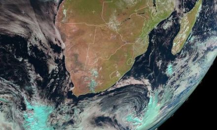
This week has seen a persistent anticyclone hold sway in the middle levels and across the regular 20 to 30oS latitudes over the Atlantic. The departures from this scene include quite frequent vortex patterns developing adjacent to these middle levels (but to our south) above the ocean and into the adjacent sub-continent. Unusual stormy weather for the time of year is the regular response.
Congo moisture has spread into Angola and western Zambia so forming a source for a southerly advance and outflow, but to our east. The Kavango region has experienced a shower or two. But the cohesion of airflows at the various levels remains disparate, hence seemingly favourable patterns cannot keep their cohesion and they fail to develop into a more active weather pattern.
One may see this as a reflection of the equatorial Pacific scene. The surface elements of La Nina have long faded. In its place, a developing El Nino pattern has stumbled with conflicting detail both positive and negative. The so-called Southern Oscillation, i.e. the difference in barometric pressure between Darwin and Tahiti, is still marginally positive, but weak.
From this situation, we found the immediate expectations for the past week equally displaced.
Temperatures in the northern half of the country remained in the low thirties with some advection of moisture across the Okavango and the Caprivi but showers were far apart and of very low intensity.
In the southern half, morning have been typically cool with a prominent south-westerly airflow, backing to north-east during the day and then reverting to south-west when the sun sets.
What’s coming?
Apart from the Okavango, the dry, hot prospect for much of the country remains unbroken.
A middle level trough departs the western Cape by Monday, a cooler northward spread fades quickly, heat returns to the southern daytime hours. The moist air presence to central Angola persists and is tapped to flow south, east of the heat low across central Botswana. With the overall upper-air presence remaining in place, this prevents a westward drift by the heat-cored low pressure area: scant change is to be expected throughout. Fine hot weather is expected by all the forecasts.