


The Week’s Weather up to Friday 15 September. Five-day outlook to Wednesday 20 September 2017
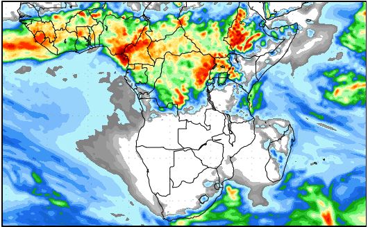
Map: Accummulated precipitation forecast for the nine days from Friday 15 September to Saturday 23 September. Source. GrADS/COLA, George Mason University.
Two prominent features stand out in this week’s weather development. The first is the almost total collapse of the southern Indian high pressure cell and the second is the powerful anti-cyclonic alto circulation over the sub-continent.
The cut-off low that developed last week ahead of the South Atlantic high pressure cell did not dissipate as easily as expected. It did not move into the southern seas either but remained more or less on the same longtitudinal track on its eastward journey and it stayed reasonably strong.
The result was an extended low pressure system that covered most of the southern Indian Ocean by Wednesday, remaining strong with a vortex measuring 958 mB at Amsterdam Island just north of the 40°S latitude. The secondary result was the movement of the core of the low pressure area between Kenya and India. For the first time this season, that core is now a not-insignificant distance south of the equator, sitting comfortably in the southern hemisphere.
The map above, while perhaps irrelevant for the sub-continent now, illustrates one important aspect of local weather during the winter summer transitional phase. This is high pressure control in the upper levels of the atmosphere, or so-called ridging.
The map shows that for the next week hardly any precipitation will fall anywhere in southern Africa excluding the eastern Cape littoral. The reason is the strong anti-cyclonic circulation over the sub-continent. On Wednesday and Thursday, the core was centred over central Botswana. That these conditions are expected to continue for at least another week, is what the map says.
Notice that the large blank disk that covers southern Africa is roughly circular in shape with a marked protrusion over the ocean between Mozambique and Madagascar. This circle discribes the outer limites of the anti-cyclonic circulation.
Despite the relatively lower pressure over land during the day, the fact that the circulation is anti-cyclonic indicates that the air’s tendency is to descend. When air descends, it compresses releasing energy hence the hot afternoons. Also, when air descends it suppresses cloud formation and despite humidity between 30% and 60% depending on the location, cloud formation is inhibited. All of this can be seen on the map.
The South Atlantic high pressure cell, however, was a beast of another kind. Earlier in the week it stretched all the way from the African coast to the South American coast. It had a reasonably strong core at 1032 mB and it was massive in extent covering more than 5000 km from east to west. That high made landfall late on Thursday which is the reason why the nights remained surprisingly cool in the Namibian interior.
Where the continental anti-cyclonic circulation encountered the South Atlantic high, an extensive convergence zone formed which covered most of the Western Cape on Thursday and Friday.
The northern arch of the convergence zone could be seen in Namibia along the coastline north of Walvis Bay up to the Kunene River mouth. Excessive fog was clearly visible on Wednesday, Thursday and Friday on satellite imagery.
What’s Coming
The South Atlantic high moves across South Africa during the weekend. It will bring cooler nights to the Karas Region on Saturday and Sunday.
The northern two thirds of Namibia will experience much the same conditions as this week with only a small chance of a trough forming over Kavango West and Bwabwata.
However, because of the prominent north to south airflow, moisture is advected all the time and scattered clouds may be seen over the interior from early evenings.
As the South Atlantic high migrates to the east, it is expected to collapse again, same as this week while that part of the high that stays behind over the South Atlantic will remain strong. If the southern Indian Ocean is again controlled by a low pressure system, it creates space for the core of the low pressure system between Kenya and India to move further south.
That may help to re-invigorate the so-called Indian Ocean transport, the mechanism that advects moisture into central Africa. It will however not have an effect on Namibian weather over the next ten days.


