


Overview for the week and 5-day outlook to Wednesday 27 June 2018
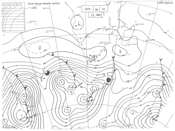
Visual: Synoptic map for southern Africa as at 12:00 on Friday 22 June.
Source: South African Weather Service, http://www.weathersa.co.za/observations/synoptic-charts
What Happened
This week turned out to be a very regular mid-winter week, progressively becoming warmer as the South Atlantic high pressure cell moved across the sub-continent from west to east. The Friday morning synoptic map shows a fairly complicated pattern but most of the action was south of the high pressure cell, with only intermittent, surface-based action along the west coast.
The map’s outstanding feature is the elongated high pressure cell that formed as the South Atlantic cell merged with the continental cell during Thursday. This leads to another local weather paradox since the high is by definition cold. But it is the leading rim of the approaching South Atlantic high that advects cold air from the Antarctic and when the cell has the shape it has on the map, then it effectively becomes a buffer deflecting the frigid air away to the east, preventing sub-zero temperatures in Namibia. This is a very common occurrence during winter and the main reason why Namibia, although cold during winter, only receives the odd really cold blast maybe three or four times.
The presence and shape of the high has another local effect though. The air in the high is cold when it arrives, typically between 12°C and 16°C since it originated in the South Atlantic and the air temperature is determined by the water temperature. When it moves over land, it moves slowly being a high pressure cell, so it warms up quickly during the day, sometimes by as much as 15°C. The effect is the typical Namibian see-saw pattern that oscillates on a daily pattern. The air is cold and dense to start with, then it heats up, rising becoming less dense, but this depends on the amount of energy exceeding the natural terrestrial radiation level. When the sun crosses its zenith, the system starts losing energy again, and the air sinks, albeit ever so slowly. This produces a warm afternoon but the air is still cold and dense, so it quickly reverts to its original energy level the moment the sun sets. Cold nights with quiet but pleasantly warm days are the Namibian winter signature.
A third element which helped raise temperatures this week was a fairly well-develop anti-cyclonic circulation over southern Mozambique in the alto levels above 30,000 feet. This is not visible on the surface synoptic map but it can be seen readily on 500mB and 250 mB maps. At that height, it arrests the force of the jetstream blowing from the west, slowing down the high’s migration across the sub-continent, effectively exposing the cold air to a longer duration of active sunshine. Simply put, the system driver (jetstream) is obstructed so the high lingers longer over land hence warmer day temperatures.
What’s Coming
As can be seen on the map, the South Atlantic high covers the better part of about 4000 kilometres. This means that its buffering effect will continue through the weekend, and into next week.
The area enclosed by the dotted line with a barometric reading of 1026mB is expected to reach the southern Namib late Monday afternoon which will lead to a colder night in the Karas region, but its effect will be very brief and by Tuesday afternoon most of the country will be back to warmer conditions.
Wednesday will be a regular winter day but, as is also typical for Namibia, the cold will come from the east as the migrating high ridges backwards over Botswana and enters Namibia along the Botswana border.
There is an outside chance for mild Oosweer from Wednesday onward but if it occurs, it will be restricted to the northern Namib.


