


The Week’s Weather up to Friday 07 July Five-day outlook to Wednesday 12 July
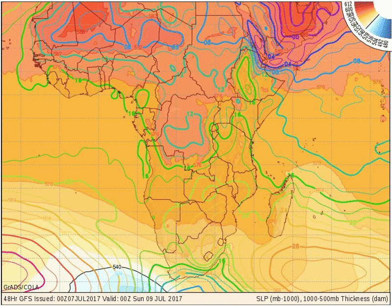
Map: Barometric pressure at sea level (colour lines) and vertical distance between 1000 mB and 500 mB contours expressed in 10-metre units
Source: wxmaps.org, GrADS/COLA
While both the southern Indian and the South Atlantic high pressure cells behaved as expected, a very prominent trough that reached some 3000 km from north to south, lay between the two highs and had a remarkable impact on both.
At the bottom (southern) end of the trough, at about 20°S, a very substantial vortex with a cone pressure of only 956 mB was driving the active frontal system that siphoned away the outer rims of both highs. Vortices of such low pressure are only found near the polar circle. Not even tropical cyclones at between 980 and 990 mB cone pressure, come close to a sub-antarctic vortex. From this, it is clear that systems this strong, must have an impact on all other adjacent systems.
The vortex lay some 2000 km south of Cape Town. Ordinarily, this may be regarded as too far off the radar to have any local impact, but the contrary was true.
On the eastern side of the trough is the southern Indian high pressure cell with its core for most of the week, almost stationery, some 500 km south of Madagascar. It had a continental extension which also remained in situ over South Africa for the whole week. The result was a strong anti-cyclonic circulation over the sub-continent, experienced in Namibia as windy conditions over the interior. Namibia being on the western fringe of this circulation, therefore had fresh to strong winds, first from the east, and during the second half of the week, from the north-east. The surface conditions were typical mid-winter for the interior above the escarpment.
West of the trough, a very strong front developed, driven by a South Atlantic high with an impressive core pressure of 1036 mB. Normally, such a system, when it makes landfall on the south-western coastline between Oranjemund and Saldanha Bay, would bring in icy cold weather with a strong south-westerly bias to the wind. That did not happen.
The vortex in the south was so strong, it basically sucked the entire frontal system to the south, missing the continent and fizzling out over southern Namibia, the Northern Cape and the Western Cape. In short, the approaching front was killed by its own driver, about 2000 km away to the south.
So far this winter, Namibia has not seen any frost. This is rather the exception, and the next two weeks will prove the severity of this winter, or lack of it.
If such strong sub-antarctic vortices continue to develop between the migratory highs, the frontal systems (cold) will be diluted, and Namibia should only experience cold nights, but not intense cold.
The prominent trough between the two highs also helps to push away any cold intrusion by bringing warmer air from southern Angola across the Namibian interior into the South African interior.
In the upper air, conditions over Namibia were very stable for the week which added to warmer days through diabatic compression late in the afternoons. Only over eastern Botswana and western Zimbabwe was an active mid-level system present leading to the unseasonal cloudiness experienced over the Zambezi Region.
What’s Coming
The weather map chosen for this week shows the pressure on the surface for Saturday 08 July up to midnight of Sat/Sunday. It shows the remnant of the high over South Africa with a weak extension to Namibia.
On the left is a black line marked 540. This is where the vertical distance between the 1000 mB and 500 mB surfaces is about 5400 metres or 18,000 feet. At surface level, the temperature is 0°C at this line, and below zero, south of this line. These cold conditions will just graze the Cape during the weekend with a minor cold intrusion into the Western Cape and Northern Cape up to the Orange River valley.
Saturday night will see some cold air penetrating as far north as Grootfontein but frost is unlikely for the reasons described in the discussion above.
A very prominent convergence line forms however, running more or less from Sandwich Harbour to Ariamsvlei. South-west of this line, it will be cold at night (limited possibility of frost but unlikely) and north-east of this line, it will be cold to mild, with warmer night conditions north of Grootfontein.
Monday, Tuesday and Wednesday next week, see mild winter conditions over most of Namibia except the Karas Region.
The next approaching, very strong South Atlantic high again bleeds away to the south, passing around Cape Agulhas with only limited impact on the continent.
As of Wednesday, conditions over the eastern half (Gemsbok Park and Botswana border) will be considerably colder than over the western half, but frost is unlikely. Oosweer is also unlikely during the 5-day forecast window.


