


Weather 29 January 2016

What Happened
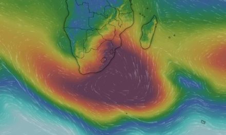
This week is characterised by a remarkable interplay between three distinct systems. The most dominant, the South Atlantic High Pressure cell slowly engulfed the continent from the south-west, bringing clear skies to the whole Namibia except for Babwatwa and Zambezi. The core of this high is situated a few thousand kilometres due west of Saldanha Bay in the Western Cape but it measures a rather subdued 1020 mB.
The second system, the southern Indian high pressure cell, lies south-east of Madagascar, its core very far off track some 3000 km away from the southern tip of the island but reading a very impressive 1032 mB. This immediately indicates that in the perpetual strife between these two high pressure systems, the southern Indian is now the strongest.
The only negative aspect is that it is a bit too far removed from the battle ground, that is the African continent, to exercise its due influence. So, for the time being the South Atlantic high has the most direct impact, as we have seen this week from the clear skies. But the strength of the southern Indian high holds much promise.
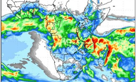
The third system is a very strong tropical depression some 3000 km east of Madagascar, more or less smack in the middle of the Indian Ocean. This enhanced cyclonic circulation acts like a massive suction pump leading to elevated evaporation from the ocean’s surface aloft into the upper levels as high as 56,000 feet. This moisture must go somewhere. It is what leads to the enhanced convection over eastern Africa.
This is where the southern Indian high comes in to play. It is the driver of the main advection system that takes Indian Ocean moisture towards the African continent, crosses the continent from east to west, and then, in a huge curve, brings that same moisture across Angola and into Namibia.
At this point, the Indian Ocean is still warmer by about 1oC, which will lead to more cyclones of high intensity from now until April. The tropical depression over the Indian Ocean has been there for over two weeks, so its contribution to continental moisture must be immense. This is witnessed by the strong zonal flow from east to west in the upper levels, and by the well-defined Inter-Tropical Convergence Zone which sits across Africa from Angola / Gabon, through to Tanzania / northern Mozambique.
By Thursday there was some upper level high pressure control over Tanzania and the Congo but this originated from the winter conditions north of the equator over the Sahara and should abate quickly since we are now more than a month past the austral summer solstice.
What’s Coming
The Inter-Tropical Convergence Zone maintains a strong, well-defined presence with its southern boundary smack on the Namibia Angola border. It is a small step to move south and enter Namibian airspace. The driver for this is also present in the form of high pressure control over the southern Mozambican Channel.
The El Nino in the Pacific Ocean seems much reduced. The 2-degree anomaly covers an area east of the dateline from 170W to 105W but the core 3-degree anomaly has shrunk to a relatively narrow strip from 160W to 140W.
The southern oscillation index from the Australian Bureau of Meteorology is at an unprecedented minus 23.6, but when it is this far negative, there is much room for a rapid upward adjustment and it is usually at the end of one of the upwards spikes that Namibia gets 4 to 5 days of rainy weather.
Over the weekend, the southern half of the country is still under high pressure control, while the northern half sees some advection with cloudy skies from Rehoboth further north. As the high departs, it creates room for the familiar mid-level trough to develop, first in the north-west over Kunene, and then spreading towards the south-east.
This process starts by late Sunday afternoon when considerable cloudiness will start over Kunene, slowly covering the whole country over the next two days. The low pressure over the coastal plain and escarpment brings very windy conditions to the Namib south of Hentiesbaai, and to the Karas Region.
By Monday conditions are ideal for another 3 to 4 days of rain from the Kunene down to the Orange.


