


Fortnightly weather overview and short-term outlook to Wednesday 11 September 2019
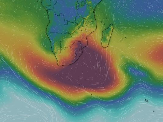
Visual: Computer general synoptic map of surface pressure and airflow direction as at Friday morning, 06 September.
Source: www.windy.com/-Show-add-more-layers/overlays?pressure,-17.225,49.570,3
Recent Developments
The mid-winter lull seems to have made way for a more active weather stance. Over the past two weeks, overall conditions has shifted noticeably with the most important that the pervasive upper level high pressure control has abated.
The previous weekend brought us only the second seriously cold intrusion this winter. This was made possible by the absence of a high pressure cell immediately south of Cape Agulhas, and by a strong anti-cyclonic circulation (much stronger than during the winter) over the subcontinent’s interior.
Perhaps the most important gradual change is one that is not so readily visible, and that is the distance between the cores of the two dominant southern African high pressure cells. In the west over the South Atlantic there is always the resident high and in the east over the Indian Ocean, the southern Indian high. In between, as the South Atlantic high moves across the sub-continent on its way to become the new southern Indian high, it always linger over land, hence it is known as the continental high but this is only a transitionary stage. Essentially, it is either the decaying South Atlantic high or the waxing southern Indian high.
Once the high has departed the land, and after it has reformed as the southern Indian high south of Madagascar, its trailing rim tends to circulate back over the continent, to a large extent driving the anti-cyclonic circulation over southern Africa’s land surface area.
Thus it is important to observe the distance between the high cores since this is an indication of how prominently airflow from the north will be able to penetrate the interior. While not everybody has access to satellite imagery, it is fairly easy as a casual observer on the ground, to tell how much “space” there is between two highs. It all depends on the length of the warmer periods (in days) as opposed to the duration of the cold spells (also in days).
This is where the change in season can be noticed. Whereas a month ago, daytime temperatures were predominantly cooler over the interior with a cold or cooler intrusion every three to four days, the cold duration has now reduced to only two days while the warmer periods are between four and six days. This is a telltale sign that the distances between the cores of the high pressure cells around the southern hemisphere are increasing.
This is very important for the coming rain season because the main summer rains depend on the ability of the anti-cyclonic circulation to penetrate deep southward into the subcontinent. If the highs remain too close to each other, it implies that the windows in between are also restricted, in turn leading to restricted airflow from the tropical north to the colder south.
In this week’s visual, the interplay between the South Atlantic high and the budding southern Indian high is clearly shown, complete with the reaching-back of the new southern Indian high over the eastern fringe of the subcontinent. The blue triangular area over north-western Namibia shows the beginning of the formation of a trough, which is what is required to bring warmer air from Angola into the Namibian interior.
On the Radar
The weather stance now shows a distinctly early-summer pattern with frontal systems being deflected around Cape Agulhas and not crossing over land.
Over the weekend, the interior will be windy due to the large pressure differential between the Botswana interior and the Namibian coastal plain.
Late Oosweer can be expected during Saturday over the central Namib but only south of Walvis Bay. Conditions in the Kunene region will be quiet but hot. On Sunday, the chance for Oosweer north of Walvis Bay increases and it will be very hot in the Namib across its entire length.
By Monday conditions will be quiet over the entire country with an outside chance of a very weak cut-off low forming between Walvis Bay and Lüderitz. If a low-pressure system develop along the coast, the southern Namib will be very windy on Tuesday.
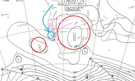
Wednesday sees a very typical early summer pattern with the core of the South Atlantic high about 2500 kilometre offshore and the southern Indian high just south-south-east of Madagascar. The distance between the two cores will be between 5500 and 6000 km, indicating that there is much room available over the entire subcontinent for airflow to intrude from the tropics. This is a very good sign.


