


The Week’s Weather up to Friday 31 March – Five-day outlook to Wednesday 05 April
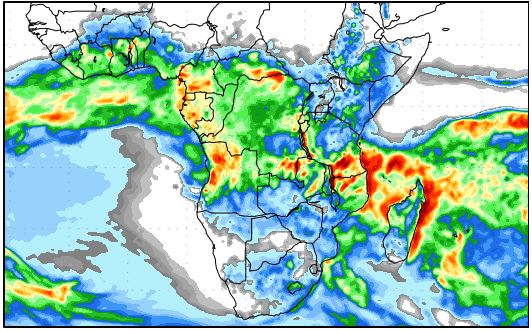
Precipitation forecast from Friday 31 March to Saturday 08 April
Source: wxmaps.org, GrADS/COLA
When the season transitions from a summer to a winter stance, the daily interaction between opposing systems becomes visible.
For the duration of this week, the noticeably cooler nights had an impact as far north as Grootfontein. The unseasonally colder early mornings were as much a result of high pressure control from the south as it was from an easterly airflow, later in the week, advecting colder air all the way from the southern Mozambican Channel. This was the same high pressure cell whose core shifted from south-west of Cape Town to east of the South Africa east coast. In its migration around the continent, it displayed more winter than summer characteristics.
But the tropical systems that originate north of Namibia still displayed a typical summer pattern. The airflow from the Indian Ocean across the continent is still enhanced, the Inter-Tropical Convergence zone remains strong and well-demarcated, and it stretches from north-east of Madagascar all the way across the continent right up to the Angolan coastline. For the past three weeks, the western section of the Angolan highland have received far above normal rainfall. The result we see in the levels of the Kunene and Kavango rivers, both of which are very high.
The oscillation between southern and northern systems was empirically observable this week. During the night temperatures fell considerably, escpecially over the southern half and wind flow was consistently from the south south-west. As soon as the sun has risen, the temperature started rising rapidly while the wind flow backed around to north north-east.
This is a typical intra-seasonal pattern in the period following the equinox. When the source of energy is removed from the mix, the high pressure control from the south-west gains the upper hand. When the sun rises, the source of energy quickly flips the surface conditions around, lending strength to the tropical system which then moves across Namibia from the north-east up to the escarpment. The moment this system crosses the escarpment from east to west and the air descends to the coastal plain, we get Oosweer like last week and this week again. The Oosweer however, was strongest over the northern Namib and basically absent from the southern Namib. This is indicative of the battle between the two systems – tropical and temperate, or put differently, between low pressure and high pressure systems.
The battleground between these systems is Namibia. This week was a textbook example of how the convergence line can shift by as much as 600 km in a single day. So while there was a promising build-up of cloud at the beginning of the week, the high pressure control on the surface systematically crossed the entire Namibia, clearing all the cloud. The high was so much in control, it dispelled all rainfall, not only in Namibia, but in South Africa, Botswana, Zimbabwe and even western Zambia as well.
By Friday, the high pressure system had a reach as far north as Tanzania with relative humidity over the entire southern Africa below 30%.
What’s Coming
The whole country remains under the control of the high pressure system for the duration of the weekend. Some cloud may form north and east of the convergence line, but these will disappear in the late afternoons. The inferred cloud base is expected to remain elevated at around 15,000 feet, another indication of the high’s impact on the surface.
Two cold fronts pass the Cape in quick succession on Saturday and Sunday. Early mornings in Namibia will remain cool, with the cold first coming from the south and then towards Monday morning, from the east. The cold fronts at the Cape undermine the development of the core of the next South Atlantic high pressure cell which is expected to measure only 1018 mB. This indicates windy conditions, first over Karas and Hardap and then by Monday, over Omaheke and Otjozondjupa.
Rainfall expectations for the next five days are zero.


