


Weekly overview and short-term outlook to Wednesday 10 April 2019

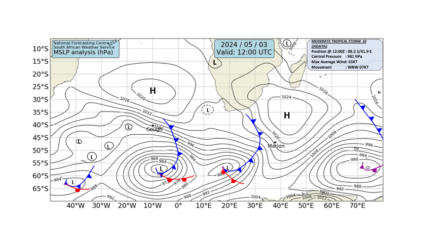
Visual: Synoptic chart of southern Africa for Friday morning, 05 April.
Source: South African Weather Service, www.weathersa.co.za/images/data/specialised/ma_sy.gif
Recent Developments
The remnant of the previous weekend’s trough brought intermittent rain across large parts of Namibia’s northern half and the eastern parts along the Botswana border. The overall pattern was a continuation of the weekend’s strong system displaying the same erratic behaviour.
Many areas received their first substantial rain for the year over the weekend yet the actual falls were scattered and differed widely in intensity. On average, the central parts received between 25 mm and 35 mm but there were many areas reporting only 16 mm for instance. This system was marked by a low cloud base and good convection. The cloud coverage was also good, covering about two thirds of the whole country.
The bias was in the west and this is also reflected in the rainfall figures. Whereas several lodges along the Kavango river reported only drops or a maximum of 5 mm, the western regions reported falls from 4.5 mm at Ruacana to an unconfirmed 98 mm neat Mount Etjo. The Omaruru district also reported good falls but as far as could be established, the river did not flood and flowed only moderately.
This system continued into Tuesday but was restricted to the areas north and east of Windhoek. Tuesday afternoon saw some spectacular heavy showers in the vicinity of Hosea Kutako International airport with several rivers actively flowing.
The areas south and south-east of Windhoek reported only a few straggling showers of less than 5 mm.
By Wednesday, high pressure control on the surface resumed and the skies cleared, followed by a blue heaven on Thursday and Friday. The only exception was the area between Nkurenkuru and Rundu where good cloud formation continued with some very isolated falls that reached into the Otjozondjupa region along the Botswana border.
The visual shows the positions of the South Atlantic High and the southern Indian High as on Friday morning. Roughly midway between the two cores is a significant frontal system that brought light but sustained rainfall to the Western Cape. This system extended northward up to the Orange River valley with much cloudiness, but little if any precipitation.
It was also noticeable that while relative humidity close to the surface exceeded 45% early in the week, this plummeted later in the week, registering less than 20% on Friday in Windhoek.
The cloud base showed a similar pattern. Early in the week it sat between 10,000 and 12,000 feet over the interior east of the escarpment but by Friday it has reverted to its more usual elevation at 16,000 feet. This is indicative of the growing high pressure control as the week proceeded.
On the Radar
A strong low-pressure system develops over the weekend just offshore Cape Town and is expected to move northward as far as Oranjemund during Sunday. This may bring some moisture to the eastern half of the Hardap region and possibly the Karas region but the forecasts do not agree on the extent of the intrusion.
The system that brought light rain this week survives in the north-east with a narrow band of moisture continuing from Angola through Kavango West into the Botswana interior where the brunt of the rainfall activity will be seen.
The red arrow on Friday’s synoptic chart circumscribes more or less the extent and the route of the vapour travelling from the Indian Ocean across the continent to the Angolan interior. As a rough indicator, the areas east of the red arrow have a reasonable chance of precipitation, ranging from very light, brief showers to more complex thunder showers.
The area west of the red line is dominated by high pressure (blue arrows) and is unlikely to see any cloud or rain.
As the high pressure cell migrates to the east (green arrow) on Monday and Tuesday, high pressure control spreads deeper into the interior from the south-west, indicating clear skies over Namibia except for the areas near the Kavango and Zambezi rivers.
By Wednesday, the trough has regained some of its strength but will only affect the eastern-most areas along the Botswana border. But as has happened often in the past, the system may wander west contrary to expectation, and then the Namibian interior may again see two or three days of rainy weather.
At this stage in the season, it is important to track the position of the Inter-Tropical Convergence Zone. Its southern boundary has retracted deep into Angola during the main part of the Namibian rainfall season which resulted in the drought. Since about middle March, it has moved back to within a hundred kilometres or so from the Namibia Angola border. The US Government’s National Oceanic and Atmospheric Administration (NOAA) expects it to move slightly further south still, and that has the potential to produce some late-season rain for Namibia.


