Weather 06 March2015
![]() What Happened
What Happened
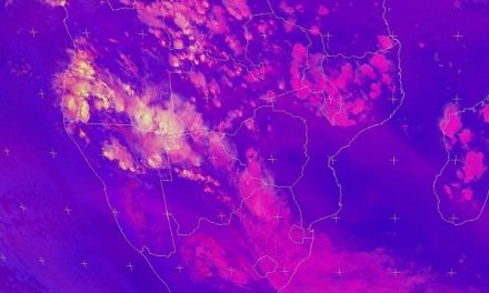
At the beginning of the week, the synoptic map showed the South Atlantic high pressure cell more or less in its customary location west of the continent with its core some 1500 km out to sea in line with Saldanha Bay in South Africa. The preceding high pressure cell has just started moving over eastern South Africa also bringing its customary strong airflow from south to north in the Mozambican Channel. The anomalous synoptic feature was the presence of a very strong vortex about 600 km south of Cape Agulhas. It is not unusual to find well-developed vortices between two high pressure cells but then they are normally much farther south. Typically, the South Atlantic high will have a much stronger influence on the surface in Namibia but the strong vortex east of the high (and so far north) bleeds away the strength of the outer perimeter of the high pressure cell. The second effect originating from the vortex is the formation of a rather prominent trough across Namibia from Iona in Angola in the north-west to the eastern corner of the Karas Region.
This trough is a very wide, very substantial conveyor of moisture from north to south and it was witnessed every day of this week as it brought considerable cloudiness from the Kunene Region through the central axis of Namibia into the Karas Region and beyond into the Northern Cape Province. Conditions were ideal for more substantial rainfall, but as has become the hallmark of this season, the two high pressure cells either side of the trough, proved to be the limiting factor. The South Atlantic high pressure cell is a formidable weather element. It is cold and dense and slowly rotates anti-clockwise. It also migrates from west to east influencing our weather accordingly as it makes landfall on the southern Namib coastline. As it encounters the continent (land) solar radiation heats it up and its barometric pressure decreases but it still remains a dominant factor. Then it slips around Cape Agulhas and moves towards the Mozambican Channel. In Namibia, its effect is felt mostly on the surface, manifesting its presence by the cool nights we experienced this week, and have been experiencing for the past month and a half. This is out of kilter showing the high pressure effect reaches much farther north than usual. Over Namibia, it control conditions on the surface over the south-western half. Meanwhile, the high pressure cell south of Madagascar advects a strong airflow from south to north which curls around, forming a large wheel that covers northern Mozambique, Zambia and southern Angola. From there, it enters Namibian airspace but now at a much higher altitude. It is witnessed by clear conditions over eastern Africa. This dynamic stage is what we saw this whole week. Moisture comes in from the north in the middle layers between 15,000 and 30,000 feet. As it crosses Namibia, it encounters the outer fringe of the South Atlantic high which hugs the surface. This pushes up the cloud base to around 12,000 feet, thereby limiting convection, and consequently precipitation. Meanwhile, over eastern Africa, high pressure controls the upper levels and we see the effect as clouds that lack structure. Cumulonimbus formation is weak and the cloud tops fail to reach 45,000 feet. It is the all-too-familiar picture of the entire season, and it was vividly on display again this week.
What’s Coming
The trough remains extant during Friday but it gradually weakens during the weekend over the central plateau. However, since its airflow is from north-west to south-east, moisture accumulates over the eastern parts of the Hardap and Karas Region (Kalahari) where rainfall of medium intensity is a strong probability. Vestiges of the trough also remain at its point of origin in the Kunene Region so some light rain is possible over the Kaokoveld. The central plateau clears somewhat with only scattered cloud building up late afternoons as moisture still enters Namibian airspace in the middle levels. Except for the western sections of both the Hardap and Karas Regions, and the southern Namib, the lingering presence of the trough over most of the country will lead to scattered cloud over a very widespread area. This will produce intermittent showers where positive conditions develop but rainfall will be limited to less than 15mm in any particular locality, be it the north, the central plateau or the southern regions. These conditions persist throughout the weekend and into Monday and Tuesday next week. The excessively high temperatures in the Hardap Region (South) and in the Oshikoto Region (North) seem unlikely to occur again for the time being.