Understanding Weather – not predicting –
What happened?
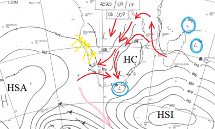
This past week an unusual synoptic pattern has held sway across the southern hemisphere. A major anticyclone with core pressures well above 1030hPa straddled the Date Line (180o) in the south Pacific while on our side, a complex low pressure pattern covered most of southern Africa and the southern oceans.
Both high and low pressure systems have been static for this period. Static in position but active within themselves: anticyclonic strength ensured a consistent flow to maintain La Nina’s, positive oscillation, and dominance of global weather.
The complexities of the vortex areas see one core deepen, drift somewhat eastward while in the cold, unstable polar air behind it a secondary vortex quickly forms, weakening the older core, then the same cycle is repeated. The effect of this pattern maintained a zonal flow throughout the troposphere (surface to 40000 feet) above southern Africa.
The unusual feature is that these differing systems have held their geographical placing while whatever else may be on the weather map either by-passes or collapses while these two major systems remain.
The other unusual feature is the global situation on either side of globe: the high and the low. Again, the effect saw a limited, if not absent, eastern Atlantic anticyclone, and similarly an absence of the western Indian Ocean anticyclone.
This departure from the norm means there is no lower level moisture input from the Indian Ocean, so with no push from the east, the heat-low pressure belt across southern Africa remains static ensuring that over Namibia there has been an advection of bone dry southerly air. This limits daytime temperatures but with no anticyclonic thrust it cannot undercut the heat-low. Without convergence, there is no cumulus cloud and no rain!
The thin layer of cloud visible has too little moisture but its presence offers hope for improvement as November wears on.
What’s coming?
The vortex pattern persists. The weak South Atlantic anticyclone remains limited throughout the period and because there is little ability to ridge round the continent, any development of a cell away to the east is restricted. Any prospect of late Spring showers depends on the persistent heat-low generating an upward convective extension to tap the adjacent moister air mass gathering above much of Zambia, linking with the equally adjacent Congo air mass then to advect this combination into our Kavango area or further west.
Current outlooks show a mixed set of patterns across the northern mid-subcontinent. Much of the data available is based on satellite images showing cloud coverage and direction of movement. Other observational sources in that area are, largely, non-existent. This data provides the grist from which computer models are built. Otherwise, it is up to a weather observer to assess what is seen to be present and offer an outlook regarding what the current situation will be able to evolve. The heat factor is seen to be increasing and its effects, as outlined earlier, offer a prospect of showers into the new week. n the south west, temperatures will be considerably cooler with a fresh southwesterly wind as a result of the high ridging in from the south Atlantic.