12 September 2014
![]() What Happened?
What Happened?
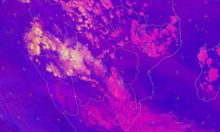
In the southern hemisphere, when a pocket of air descends, it slowly starts revolving in an anti-clockwise direction. When another pocket of air rises, its starts a clockwise rotation. Through the associated humidity, traces of these two opposing circulations can be seen, or inferred on satellite images as slowly rotating clear areas, and more rapidly turning cloudy streaks and streamlines. Over the ocean high pressure cells are indicative of cold water while their kin, the low pressure systems closer to the equator, are associated with warmer water. South of the so-called high pressure belt lies another zone of complex low pressure systems visible as strong vortices, but these are driven by the outer fringes of the rotating high pressure cell, and not so much by the temperature of the water.
A combination of these elements, i.e. equatorial low pressure, Atlantic high pressure, and sub-Antarctic vortices, all played their part in this week’s weather. For the past two weeks, the southern African subcontinent was controlled by high pressure conditions. Although increasing daily solar radiation tends to weaken these cells when they reach the continent on their migratory path from the South Atlantic Ocean to the Indian Ocean, they are still mighty meteorological events and do not dissipate that easily. The week started with the remains of a high pressure cell over South Africa, leading to easterly and northerly airflows over Namibia. But the next South Atlantic high pressure cell was in close proximity over the ocean with a remarkable influence, especially in the upper air above 16,000 feet. The easterly and northerly airflows were opposed, on the surface by this high pressure cell, but in the upper air high pressure reigned supreme, leading to very strong streamlines flowing from west to east.
The result was clear skies and coldish nights.
Although a vast area of lower pressure was present over the Kunene Region and Owamboland, it was not a true low pressure system. Barometric readings still exceeded 1018 mB, indicating the pervasive high pressure control. Only by Thursday did the pressure subsided to around 1013 mB, and over southern Angola to 1012 mB. Pressures above 1013 mB are typically regarded as higher pressure while those readings below 1013 mB are called low pressure areas. But these definitions are mostly based on convention and in real-life weather conditions, the pressure differential often plays a much bigger role in local weather conditions, than the actual value itself.
The low pressure circulation which started developing over southern Angola on Wednesday lead to some advection over the Zambezi and northern Botswana on Thursday with some light, but scattered showers. This all but disappeared on Friday when rotation reverted to more typical conditions and a trough line became visible. It did lead, however, to hot temperatures from the Kunene to the Zambezi over the area north of the Oshivello, Grootfontein latitude.
Only by late Thursday did really hot conditions set in over the rest of the interior south of this line.
What’s Coming?
Over the weekend, for the first time this season, a proper trough develops extending from Angola to the Northern Cape Province in South Africa. The wind will be mostly from the north shifting to north-west. This trough follows the convergence line more or less from Ruacana to Aroab.
Towards Saturday afternoon, the first clouds should become visible over the north-western escarpment, with a strong flow towards the south-east. But at the same time the whole system migrates to Botswana, shifting the trough line’s position from west to east.
By Sunday, this vector movement results in much cloudiness over the Kalahari, maybe as far north as Mariental, with an outside chance for light rain. A very strong vortex is building south-east of Cape Town, driven by a prominent South Atlantic high pressure cell which should arrive by Tuesday night or during Wednesday. This will have little impact on daytime temperatures, but it should have a strong influence on upper air conditions, hence the few days of cloudy weather will be replaced from Wednesday onwards again by clear skies and very windy conditions south of Walvis Bay.